 |
Somewhere, over the Red Sea: The story of the Exodus (Part Four) Posted 21st August, 2011 |
 |
|
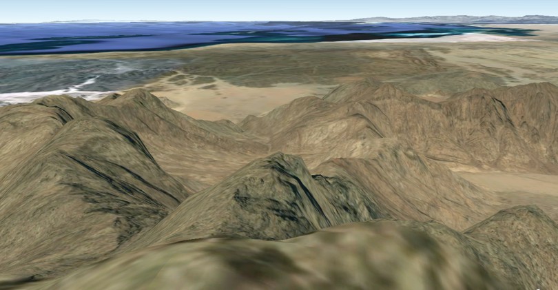
WE HAVE ALREADY GIVEN THE COORDINATES OF THE PEAK the author believes is the true Mount Sinai (27 51 35 35 44 33). The time has come to provide more evidence for this identification. If you find yourself half as thrilled as the author with the information contained here, you are in for some serious excitement. In a nutshell, we are looking for a mountain located about five days walk from the Red Sea encampment - say, roughly 30 to 60 miles. We find the same peaks mentioned earlier:
As noted earlier, the author has concluded that the true Mount Sinai must be the latter. A major factor in helping to decide between the two is the testimony of Josephus, who says of Mount Sinai, Now this is the highest of all the mountains thereabout, and the best for pasturage (Ant., II, XII, 1). Everything supports this identification. Scripture provides a number of properties that the mountain must possess in order to be considered the genuine article. By examining these details we can eliminate all the possibilities but this one peak. (It is about 100 feet higher than Ron Wyatt's chosen peak.) It has grand aesthetic appeal and is set in a beautiful landscape. Not to mention that the Red Sea, edged by what would appear to be sandy beaches, lies an easy fifteen miles away, providing the people with a perfect holiday destination. No wonder they didn't grumble the whole time they were there. An analytical chemist can identify any chemical by comparing its properties with databases listing all the "must-have" properties of said substance under control conditions. If a powder, for instance, is yellow, he can know that it cannot be, for example, sodium chloride (salt) which, as we all know, is always white. By a simple process of elimination he can quickly narrow down the field of potential candidates to a handful; from there he can pick the winner by considering some of the more subtle details. The same simple concept can be applied to help identify Mount Sinai. Properties that the true Mount Sinai must have are,
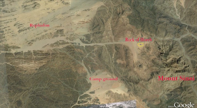
These features are not optional extras but absolute prerequisites for Mount Sinai. One cannot help but marvel at the indifference shown by some scholars towards these and other vital facts when declaring themselves in favor of a particular candidate. Emmanuel Anati (1985)49 plumps for a low peak (2500 feet) known as Har Karkom in the far south of modern Israel50 as Mount Sinai. Unfortunately for its proponents, Har Karkom fails badly against vital biblical criteria. One critical fact that must be reconciled with one's identification of Sinai is that it is an "eleven day's journey" from Kadesh Barnea (Deut. 1:2). Anati agrees: If Har Karkom is Mount Sinai, for a group that walks on foot, eleven days are indeed needed from Horeb, by the way of Mount Seir, to reach Kadesh Barnea. Who can be interested in thinking that such biblical passages are meaningless nursery rhymes?51 He then plucks out a new location for Mount Seir (not Mount Sinai) from the ether and expects us to believe his assertion that a journey between Har Karkom and traditional Kadesh Barnea52, going via his Mt Seir53, would have taken the Israelites eleven days. However, the distance is a mere 36 miles as the crow flies, making a daily walk of a little over three miles. (Most sources on the topic of a "day's journey" set it at between fifteen and twenty five miles. See "They went that-a-way" for further discussion.) In addition, any attempts to reconcile this hill with the bulleted points above - with the exception of the point about being able to see it from a distance - appear doomed. Let it be clear; the true Mount Sinai must exhibit these characteristics. Room for a ponyThe Illustrated Bible Dictionary says this about Mount Sinai: Travelling past Marah and Elim, the Israelites reached Sinai in the 3rd month after their departure from Egypt. and camped at its foot on a plain from which the top was visible (Ex. 19:16, 18, 20) (Douglas ed. 1980, p. 1461). If you Google Earth the coordinates given above for Har Kodesh, something should hit you in the eye - the perfect camp ground at its base!54 Let us not forget that the Israelites camped at Sinai for slightly under one year. Surely God would choose a campground that would provide considerable comfort for His newly-redeemed people - big enough to provide "room for a pony" (for "Keeping Up Appearances" fans), and and of a soft substrate for at least the elderly. Please explore the area for yourself. A close-up view shows tracks made by RVs, indicating a soft, possibly sandy surface, most conducive to a good night's sleep. As for area, the central, sandy zone would be about seven to eight square miles. Adding to that the numerous sandy wadis leading away from the clearing would give you up to ten square miles of soft ground for pitching tents in the near vicinity; that's close to six to seven thousand acres. Assuming a total population of three million, that would make for a density of up tp 500 people per acre. That appears too dense. But not a problem, as nothing would have prevented the fitter citizens from pitching their tents in the extensive, low, gently-sloping hills stretching to the west and north. Once again, a smaller count for the number of people involved in the Exodus solves this problem completely. None of the traditional sites for Mount Sinai has anything to compare. Zoom in on Jebel Musa and you will find nothing like it. The sole potential campsite55 is a pretty squalid-looking affair by comparison, and less than one square mile in area. And no trips to the seaside would have been possible, either. Many people would go stir crazy after a year stuck in that valley. As for Har Karkom - forget it! Of all the other sites proposed, Jebel al-Lawz alone has anything similar in area and potential comforts of home.56 Once you have explored Har Kodesh's campground, you, too, will surely proclaim with a loud voice, "It's gotta be the place". Unfortunately, Google Earth cannot show the details of the landscape at ground level. It does, however, allow people to post photos. For some reason, the area around Har Kodesh is rarely visited, as is evident from the lack of image icons there. However, these photos taken within thirty miles from the site give a glimpse of what the area may look like on the ground. Though a fairly arid area, it's still quite charming in its own right. Annual precipitation in the general area today is extremely low: the city of Tabuk, about seventy miles east, gets just under three inches per year (makes Fresno seem positively saturated), while Al Muwaylih, about fifteen miles southwest, receives a little over one inch. Back in Moses' time, precipitation was presumably higher. Which brings us to another property of the true Mount Sinai. Streams in the desertEveryone knows of the famous golden calf incident that occurred at Mount Sinai. Moses later recounted that, Then I took your sin, the calf which you had made, and burned it with fire and crushed it and ground it very small, until it was as fine as dust; and I threw its dust into the brook that descended from the mountain (Deut. 9:21). That the brook actually had water in it at the time is made clear from the parallel account in Exodus 32:20. The true Sinai must have evidence of a brook flowing through the campground. The traditional Jebel Musa may score a point on this point, as the sole possible campground has two valleys running into it that would channel water from the summit into there after rain. The presence of numerous trees suggests that water runs through here fairly often. Ron Wyatt's campground gets a very faint tick on this point, as a gully certainly does run from his peak down into it. Undoubtedly water would flow after a downpour, but the lack of vegetation along its projected course through the campground suggests it's a rare event. Har Kodesh scores a positive tick on this point, as seen in this picture snapped from 5000 feet elevation. In all likelihood Moses followed the course of this stream when he climbed the mountain to meet God.
Note the dark spots on the ground splaying out towards the camera from the point where the watercourse coming down the mountain meets the plain below. Each spot is a large tree, most likely Acacia raddiana (or possibly A. tortilis). The presence of these trees in such abundance shows that water must percolate across this plain with some regularity. The stream may well cut down to bedrock during heavy rain events, in which case it would flow roughly in lockstep with the line of trees. This stream likely flowed the entire time the Israelites were camped there. (A comparative study of the catchment areas of Wyatt's peak and Har Kodesh shows that the Har Kodesh stream is fed by an area about five times greater than Wyatt's stream.) They had to have water, and we have no record of them complaining about the lack of it. Room with a viewA critical property of the true Mount Sinai is that, as noted above, it must be visible from the campground, or at least from a significant portion of the campground: And Moses brought the people out of the camp to meet with God, and they stood at the foot of the mountain. Precisely what is intended here in terms of where they stood in relation to their tents is not clear. Maybe the people congregated as close to the foot of the mountain as possible without actually "touching" the mountain, which had been strictly forbidden. In that case, they could just see the summit rising above lower peaks in the foreground, as seen in this picture.
Of course, the further one moves away from the very foot of the mountain, the better the view of the peak. This picture gives us the flavor of what the Israelites would have seen from near its foot. They may have stood further away, as possibly alluded to in Exodus 20:18: Now all the people witnessed the thunderings, the lightning flashes, the sound of the trumpet, and the mountain smoking; and when the people saw it, they trembled and stood afar off. The summit is about eight miles distant from the centre of the campground, possibly explaining the statement that the people "stood afar off". This picture gives an idea of the view from a mile back from the base.
A better view still can be gained by walking about six miles south from the camping area to a higher elevation from where the view is unobstructed by intervening hillocks.57 57 This spot still fits the description of being at the foot of the mountain.
In short, a number of options are available as to where the people could have stood at the mountain's foot. The same could not be said for Jebel Musa. Let's turn the tables now and take a Moses'-eye-view of the campground and surrounding scenery.
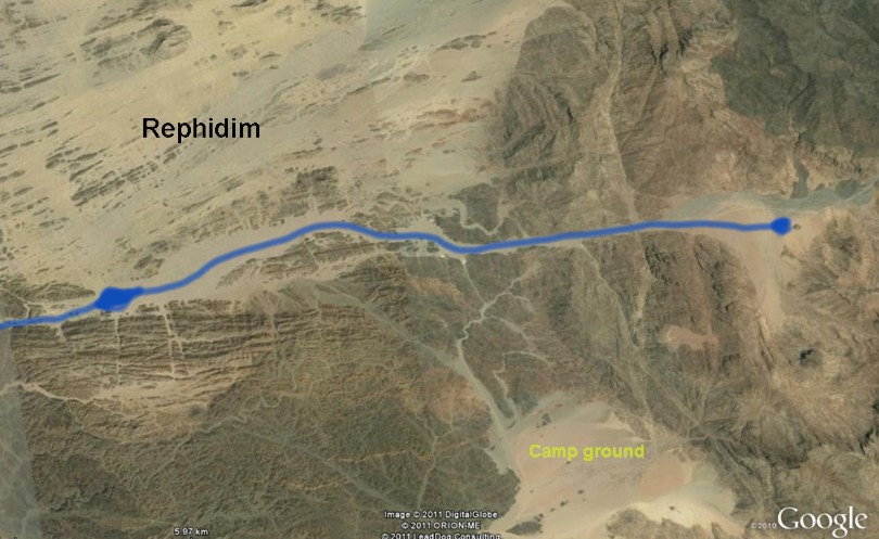
Isn't that spectacular? The Red Sea is plainly visible, and to the top right of the picture you can see a portion of Rephidim. But we are getting ahead of ourselves. We'll get back to that shortly. This ability to see the summit from the camping area is totally lacking at traditional Jebel Musa. On that one point alone you can scrub it off the list of possible candidates. Ron Wyatt's peak is visible from his campground, so it remains a contender on this basis. As for Har Karkom, one cannot find a suitable campground let alone figure out if the peak (if you will pardon the exaggeration) is visible from it. The rock of HorebIn recalling the epic wanderings of his ancestors, the psalmist's harp of inspiration waxed eloquent about a remarkable miracle that occurred more than once: He split the rocks in the wilderness, and gave them drink in abundance like the depths. He also brought streams out of the rock, and caused waters to run down like rivers (Ps. 78:15-16). In order to see the relevance of this passage we need to examine a fairly lengthy section from the book of Exodus: Then all the congregation of the children of Israel set out on their journey from the Wilderness of Sin, according to the commandment of the Lord, and camped in Rephidim; but there was no water for the people to drink. Therefore the people contended with Moses, and said, "Give us water, that we may drink." And Moses said to them, "Why do you contend with me? Why do you tempt the Lord?" And the people thirsted there for water, and the people complained against Moses, and said, "Why is it you have brought us up out of Egypt, to kill us and our children and our livestock with thirst?" So Moses cried out to the Lord, saying, "What shall I do with this people? They are almost ready to stone me!" And the Lord said to Moses, "Go on before the people, and take with you some of the elders of Israel. Also take in your hand your rod with which you struck the river, and go. Behold, I will stand before you there on the rock in Horeb; and you shall strike the rock, and water will come out of it, that the people may drink." And Moses did so in the sight of the elders of Israel (17:1-6). This passage presents a puzzle which is readily solved with the help of good old Google Earth. Where is the problem? Note: God instructs Moses to go from Rephidim to Horeb (Sinai) to a particular rock and to strike it. Upon doing so, water would start to flow from the rock at Horeb and would solve the problem of lack of water in Rephidim! Note this fascinating comment from Stone's Chumash: . since the miracle would take place in Horeb, which was some distance from Rephidim, it was necessary to take the elders to see what was about to happen. Once the rock was split, the water flowed to the nation in Rephidim (Scherman, p. 390). What is going on here? Many have debated whether Horeb and Sinai are one and the same peak or two neighboring peaks; we will take the consensus opinion that they are synonyms for the one mountain, a position thoroughly supported by implication from Malachi 4:4. When this rock at Mount Sinai gushed like a geyser the water didn't flow into the Sinai campsite but into the Rephidim campsite. Let's see how it all fits by examining this picture.
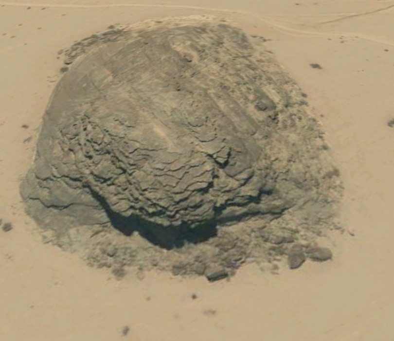
This picture shows the logical location for the campsite called Rephidim. We will talk more about it shortly. First, more about the rock at Horeb.59 For one thing, it's huge, being roughly 600 feet long and thirty feet high. Small wonder it is referred to in Exodus 17:6 with the definite article - it's not just a rock, it's the rock. Here is a close-up:
Dare I ask? Does it appear in any way split to you? This picture explains why this rock is linked with Mount Sinai.
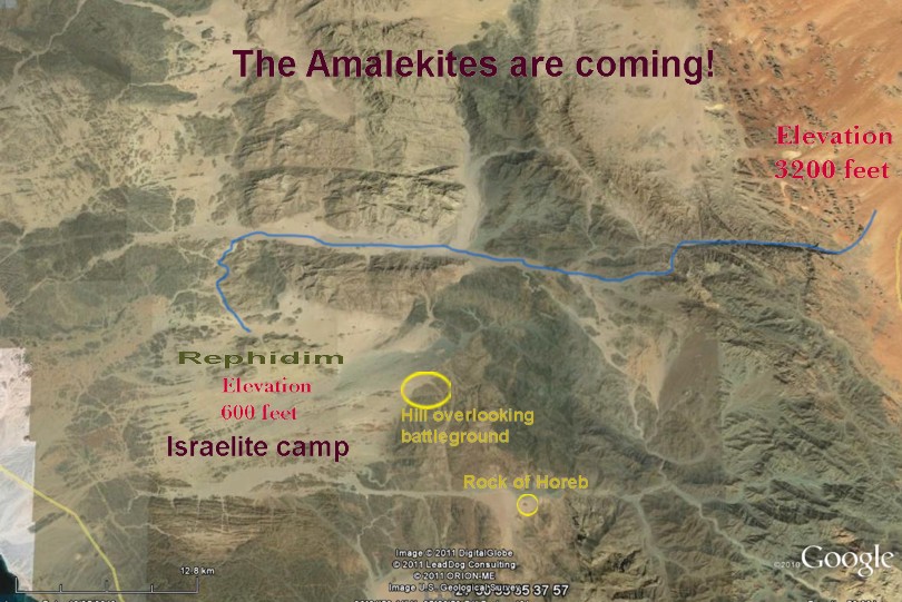
As you can see, it's virtually at the foot of Mount Sinai. Elevation data show that the raging torrent of water that poured from this rock flowed straight along the natural wadi for ten miles until reaching the Rephidim campsite.
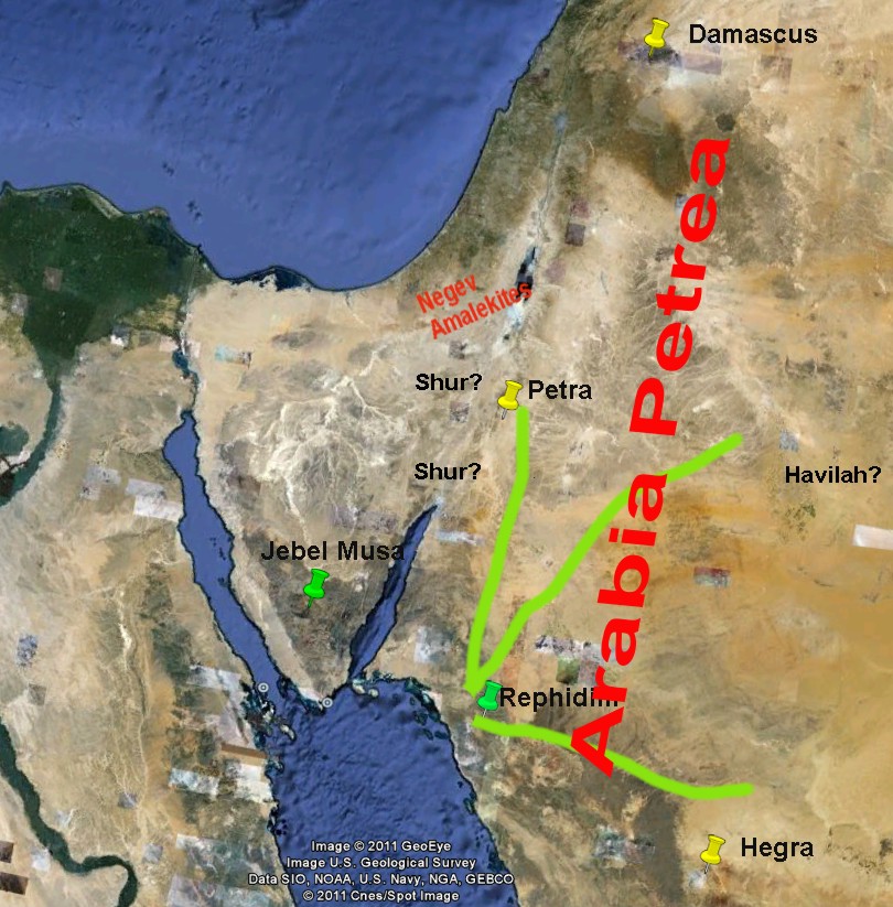
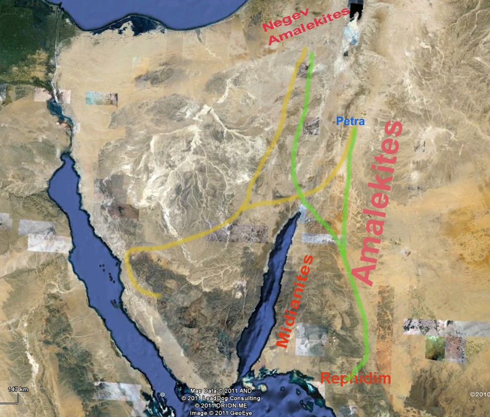
Note that the pooling indicated in the left side of the picture is not a matter of wishful thinking. You can verify for yourself that it would have pooled here by studying the elevation data on Google Earth from close-up. Look, you can find lots of rocks on this planet, so to dogmatically assert that this rock has to be the rock would amount to the height of folly. (Proponents of Jebel al-Lawz have their "rock at Horeb"60 to which they are passionately devoted, and cannot conceive of its being misidentified. ) But this author is quietly confident that you have now laid eyes on the rock of Horeb. It all fits. Beautifully. The Amalekite death wishNow we can go backwards in time from the Israelites' arrival at Har Kodesh to their experience at Rephidim, about ten miles by foot from the Sinai campsite. Consider what the Bible has to say about their time here: Now Amalek came and fought with Israel in Rephidim. And Moses said to Joshua, "Choose us some men and go out, fight with Amalek. Tomorrow I will stand on the top of the hill with the rod of God in my hand." So Joshua did as Moses said to him, and fought with Amalek. And Moses, Aaron, and Hur went up to the top of the hill. And so it was, when Moses held up his hand, that Israel prevailed; and when he let down his hand, Amalek prevailed. But Moses' hands became heavy; so they took a stone and put it under him, and he sat on it. And Aaron and Hur supported his hands, one on one side, and the other on the other side; and his hands were steady until the going down of the sun. So Joshua defeated Amalek and his people with the edge of the sword (Ex. 17:8-13). Students of human behavior and geopolitical decision-making could barely choose a more illuminating, albeit puzzling, topic for their investigations than the decision by the Amalekites to attack the Israelites. Who in his right mind would launch a full-on assault against a people who had emerged unscathed from the depths of the Red Sea while their erstwhile enemies had perished to a man in its depths? Implacable hatred alone seems capable of explaining their action. Reading between the lines suggests that the Amalekites arrived late one afternoon, possibly the very day the refreshing waters had reached the Israelite camp and given the Israelites renewed confidence, and immediately engaged the Israelites in an exploratory skirmish. That night Moses called his war cabinet together to plan the next day's strategy and tactics. The vast, flat, gently-sloping plain - about seven miles by ten miles - appears to have been prepared for this year, this week, this day, this hour. It lent itself perfectly to military planners of genius. Its extensive, open, flat areas lent themselves to engagement by pitched battle. On the other hand, the numerous rocky outcrops, formed, it would seem, where parallel ranks of dykes break the surface, could have afforded ideal cover for ambushes against any reconnoitering or fleeing enemy bands. Did Moses opt for a full-scale frontal offensive action, a defensive action behind hastily-erected fortifications, or some kind of complex guerilla operation taking advantage of the many low rocky walls? Who can know for sure? That Moses was a brilliant general is attested by Josephus, who claims he had much military experience as Egypt's "Field Marshall", during which time he had demonstrated remarkable military genius (Ant., II, X). In all likelihood, Moses put his military eggs in a number of baskets. That our Rephidim is the Rephidim is supported by another feature that fits the biblical account - the perfect ringside hill from which Moses could survey the scene.61 These pictures give an idea of the plain and the hill. At over 3000 feet high, this hill was just the ticket. Naturally, human eyes would be incapable of seeing individuals locked in mortal combat eight miles distant, and the record implies that Moses could see what was going on. In all likelihood, Moses' tactics succeeded in luring the Amalekites into pitched battle around the base of the hill where he could see everything that was going on. Platoons of ambushers had no doubt been posted behind suitable outcrops all over the plain, from which they could emerge to pick off fleeing Amalekites. That skirmishes were involved is strongly suggested by the fact that the struggle continued all day long. Whence came the Amalekites?We now ask: does this scenario make sense in light of our Rephidim's location relative to Amalekite territory? According to Numbers 13:29, the Amalekites lived in "the land of the Negev". Supporters of traditional views about Mt Sinai naturally enough consider that these Negev Amalekites are the ones who attacked Israel in Rephidim, and argue against a Saudi Arabian location for Sinai on the grounds that Amalekites living in the Negev would have ". no motive. to travel all the way down to the site to attack the Israelites ".62 True, they would not, other than hatred. However, the Rephidim gang of Amalekites came from elsewhere. The report in Numbers 13:29 that Amalekites dwelt in "the area of the south [negev]" (Scherman's translation) needs to be read in its context. This report was tabled by the Israelite spies sent to reconnoiter the Promised Land, and is restricted to what they saw there. The entire area surveyed is described in verse 21 as "… from the wilderness of Zin as far as Rehob". The Wilderness of Zin can be plotted at "the southwestern shore of the Dead Sea" (Scherman, p. 801), putting in the northern part of the Arabah. (Actually, the evidence would suggest that this wilderness is to be equated with much, if not all, of the Arabah, the section of the Jordan Rift Valley running in a north-south orientation between the southern end of the Dead Sea and the northern tip of the Gulf of Aqaba. However, the point being made here remains the same either way.) Though partly located in the Negev, this area does not constitute the entire Negev. The Amalekites mentioned by the spies lived in this restricted area, making up such a small tribe they are not mentioned in Joshua's later list of the peoples engaged by the Israelites.63 They were still in the area around 400 years later; David "went up" from the Philistine plains to do battle with them, the Geshurites, and Gezrites, all of whom are described as "… the inhabitants of the land from of old" (1 Sam. 27:8). That they were a relatively weak group is shown by the fact that David attacked them. David was brave, but he was no fool. At that time, he was a fugitive living in Philistia with a group of supporters too small to take on any Goliaths. The notion that the Amalekites spoken of in Numbers 13 should be seen as a populous group occupying a vast portion of territory known as "the Negev" (see map) does not hold up. Although this small band of Amalekites may well be the ones spoken of in Deuteronomy 25:17-18 as mercilessly cutting off helpless Israelite stragglers during their march across the central Sinai Peninsula, they likely contributed little to the Rephidim gang. The Amalekites that attacked the Israelites at Rephidim were more populous tribes living elsewhere. Where else may they have come from? Josephus helps us out here. He tells us that the Amalekites who attacked Israel at Rephidim "inhabited Gobolitis and Petra" (Ant., II, II, 1). The location of the famous ancient city of Petra64 is well-known as modern Jordan's most popular tourist destination. As for Gobolitis, Feldman tells us that, Maier has called attention to the fact that this is unequivocally identical with Arabia Petrea and that at the time that Josephus was writing it was actually the realm of the Nabateans and other Arab tribes. (2002, p. 167). It would appear that Petra was the capital city of an area known as Gobolitis in Josephus's time. When Josephus wrote - about 1500 years after Moses - the Roman province of Arabia Petrea did not yet exist. Less than a decade after Josephus died, the Romans annexed the region, at which time it became a Roman province. Since Maeir apparently demonstrates unequivocally that the Gobolitis mentioned by Josephus is "identical with" the region that became the Roman province of Arabia Petrea in 106 AD, we will find our Rephidim Amalekites there. That they did not occupy every square inch of the region in Moses' time is obvious; Midian, too, was included in this Roman province. We have no way of knowing the full extent of Amalekite occupation of "Arabia" in Moses' time, but the point is, the Rephidim Amalekites are from there, not from the Negev. Which territories were included in the Roman province? The 1970 edition of Encyclopedia Britannica tells us that, "It comprised the territory of the former kingdom of the Nabateans, with the addition of some adjacent cities." (Arabia, Roman Province of ). The same encyclopedia says of the realm of the Nabateans that, Their extensive dominions stretched from the outskirts of Damascus to the eastern shore of the Red Sea and from the Sinai Peninsula far into the Arabian desert [emphasis ours] (Nabateans). Notice that their homelands extended a long way east into the Arabian desert. And according to fairly recent archaeological finds, it went as far south into modern Saudi Arabia as Hegra, described by one author as "the southernmost city in the Nabataean kingdom. before being annexed by Rome in 106 AD ".65 Hegra is about 150 miles southeast of "our Rephidim". We need to mix in another disclaimer; although the famous city of Petra was included in the area known as Arabia Petrea in Josephus's time, it almost certainly was not occupied by Amalekites in Moses' time. The Old Testament shows that in his time an area stretching roughly thirty miles from the Dead Sea and the Arabah towards the Arabian desert in the east was occupied by Amorites, Moabites and Edomites. Josephus was undoubtedly correct in generalities but not in details. Confusion seems to reign over the question of the Sinai Peninsula's inclusion in Arabia. The Encyclopedia Britannica quoted above seems a little ambiguous. The author of the Wikipedia article "Arabia Petrea" includes the Sinai Peninsula as Nabatean territory, while the author of "Romans in Arabia"66 limits it to " modern southern Jordan and north west Saudi Arabia ", ignoring the Sinai Peninsula. Regardless of its inclusion or exclusion, the evidence suggests that the Negev Amalekites would not have been sufficiently strong to launch a full-on assault against the Israelite multitude. Though they may have contributed to the force, the vast majority of the Amalekites that attacked at Rephidim were not from the Negev but from northeast, east, and southeast of there. That Amalekites lived in the area of modern Jordan and north-west Saudi Arabia is supported by passages from the book of Judges which put them in alliance with other Trans-Jordanian peoples. Eglon, King of Moab allied with Amalekites and Ammonites (3:13) to harass Israel, while in the days of Gideon, the Amalekites, together with Midianites and "children of the east" launched a major assault against Israel. Judges describes the camp of the aggressors: Now the Midianites and Amalekites , all the people of the East, were lying in the valley as numerous as locusts; and their camels were without number, as the sand by the seashore in multitude (7:12). They may have been the junior partners in this venture; nevertheless, they appear to have been in abundant supply in that part of the world, as distinct from the smaller group holed up in the Negev of the Promised Land. At about the same time David was raiding the Negev Amalekites, God instructed King Saul to, Go and attack Amalek, and utterly destroy all that they have, and do not spare them. But kill both man and woman, infant and nursing child, ox and sheep, camel and donkey.". And Saul attacked the Amalekites, from Havilah all the way to Shur, which is east of Egypt. (I Sam. 15:3-7). These Amalekites were not dwelling in the Negev but way to the east, with their western border lying at Shur, somewhere along the Arabah south of Edom, bordering on Egyptian-controlled Sinai, and their eastern border who knows where? These Amalekites were obviously located outside the boundary of the Promised Land, while the Negev Amalekites were within Israelite territory. While many were nomads, others lived in cities (1 Sam. 15:5). By now you are undoubtedly getting the point (apologies for the repetition): the Rephidim Amalekites did not come from the Negev but from territory now controlled by Jordan and Saudi Arabia.
If the main body of Amalekites responsible for the attack came from Arabia Petrea rather than from the Negev, it should be immediately obvious that a march to our Rephidim would be shorter (about 175 miles from, say, Petra) than one to the traditional Rephidim near Jebel Musa (about 220 miles). The journey to our Rephidim would be shorter still, comparatively, from many other parts of Gobolitis. Bearing in mind that the Israelites reached Rephidim seventeen or eighteen days after passing through the sea, the Amalekites would have had more than enough time to get there from most areas of Gobolitis, even taking into account the time needed to work out a battle plan and the coordination of their movements. One can deduce the final leg of the route they took into Rephidim. It is most unlikely they would have attempted to travel through the more densely-settled areas of Midian. Commonsense suggests they would have gathered on the high plateau (over 3000 feet high) about thirty miles directly east of our Rephidim67 and then made their way towards the west down and along the large wadi to the plain of destiny. and destruction at the hands of God. This picture provides an overview of their route:
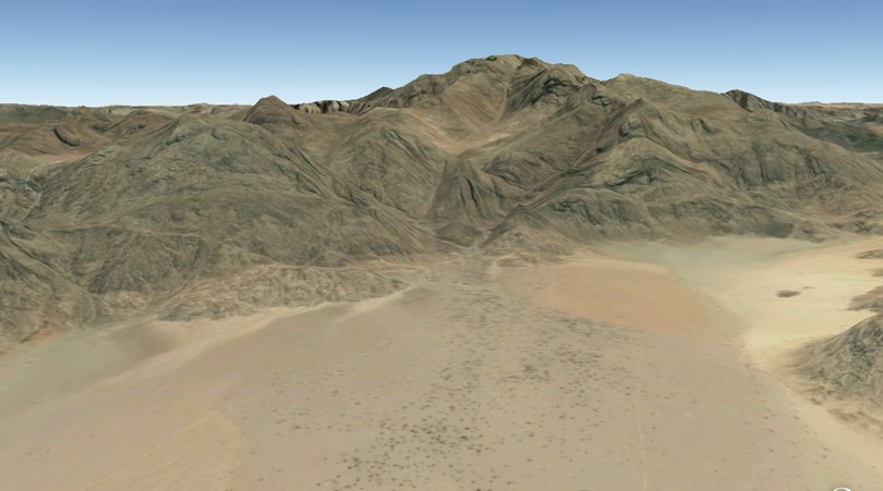
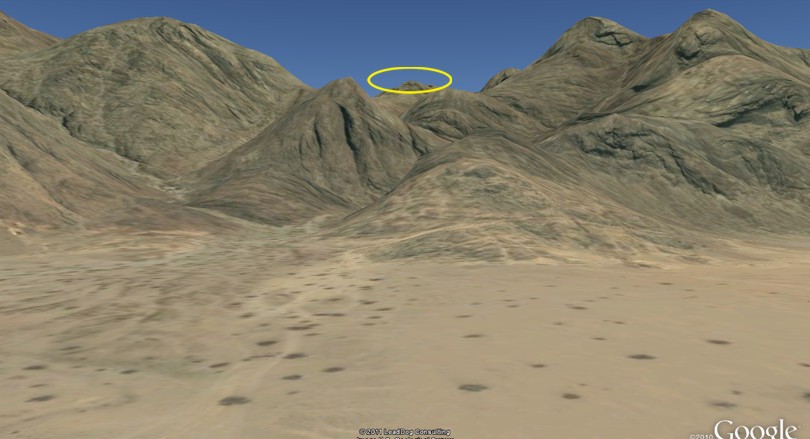
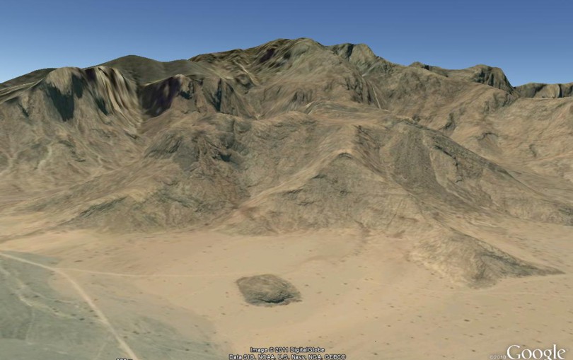
These pictures provide more insights into the Amalekite attack. AltarsAnother feature we did not include in our list of must-have properties but one that we would certainly love to find is two altars. After the battle of Rephidim, Moses built an altar there (Ex. 17:15). Later, after coming down from Mount Sinai he built an altar "at the foot of the mountain" (Ex. 24:4). Unfortunately, to find the remains of these altars, should any still be there, would require bodies on the ground. One cannot help but wonder, however, what that square object is at 27 51 01 35 38 02, right at the base of Har Kodesh. It measures five to six yards across. Those faint rings around it (scroll down); what are they? How many do you count? The presence of some kind of altar in the vicinity of a candidate peak is not proof of authentication. It would need the thumbs-up of reputable archaeologists before it can be added to the positive side of the evidence ledger. Must it or mustn't it?Some aficionados would insist on adding another property to our list of must-haves: evidence of severe burning and melting. That Mount Sinai would show evidence of being subjected to heavy-duty conflagration makes perfect sense in light of the biblical description of God's appearance there: Then you came near and stood at the foot of the mountain, and the mountain burned with fire to the midst of heaven, with darkness, cloud, and thick darkness (Deut. 4:11). Certainly, the presence of molten glassy rock around the top of a candidate peak would have to be treated with respect as evidence. Ron Wyatt apparently claimed (though the author cannot find the original source) that he had discovered such glass at his Mount Sinai, indicating the presence of intense heat, but verification seems impossible to come by. The best evidence of burning on his peak that one can find is this photo.
To this author, that picture, supposedly showing the upper 200 feet burned black, is far from convincing. What do you think of this photo? Is this one to the right more convincing? Trouble is, it's not Ron Wyatt's peak, but is posted on Google Earth near Al Maqna and labeled "black and red hill". It appears to be located about 35 miles from Wyatt's peak. Could two-toned mountains be a feature of the area? You may also want to have another look at the peak on the left in the picture posted earlier of Ash Sharaf. Besides, is evidence of burning a prerequisite for making a positive identification? Not if you take the burning bush episode as any kind of precedent. Moses saw a bush burning vigorously, but "the bush was not consumed" (Ex. 3:2). One would be advised to reserve judgment on this property; one would also be wise to show a little healthy skepticism about Ron Wyatt's claim of finding obsidian. So many true Mount Sinais have been proffered over the years. So many reconstructions have been presented of the route taken by Israel between Rameses and Mount Sinai. What makes this scenario any different? As best as the author can tell, it's the only proposal that faces no major objections from any perspective - exegetical, historical, archeological (remembering that absence of evidence does not mean evidence of absence), and logical. But don't take his word as gospel; please think it through for yourself. We conclude with a brief reiteration of the overall thrust of our thesis. The prima facie evidence covered in Part One points unmistakably to a Gulf of Aqaba crossing and a Midianite location for Mount Sinai. All searches for the true Sinai ought to embrace these as their starting point; only if no suitable "Sinai sites" matching all the available biblical data describing the Mountain of God can be found in that general area should investigators return to the drawing board and reconsider possibilities within the Sinai Peninsula. Just as an analytical chemist can sweep away hundreds of samples of chemical substances with near gay abandon in his search for one specific substance because their properties don't match the known criteria, we can do the same thing in our quest for the Holy Mountain. A simple process of elimination quickly focuses our attention on the one peak in the general area of ancient Midian that has all the necessary properties - Har Kodesh. Yes, it's just that simple. One final word. Being familiar with the route taken and the landscape traveled by the Israelites of old can breathe new life into one's appreciation of the second greatest event in human history. But we haven't dealt with the bigger question: What was it all about? Why did God make a covenant with Israel at Sinai? Read "Marvels and Mysteries of the Sinaitic Covenant" to see why this question has been so often asked yet so little understood.
49 See also HAR KARKOM AND MOUNT SINAI: EXEGESIS AND TOPOGRAPHY for an open access account by the same author [Back] 50 Coordinates: 30 17 05 34 44 24 [Back] 51 HAR KARKOM AND MOUNT SINAI: EXEGESIS AND TOPOGRAPHY [Back] 52 Coordinates: 30 40 03 34 23 50 [Back] 53 Coordinates: 30 25 44 34 44 03 [Back] 54 Coordinates: 27 50 46 35 36 41 [Back] 55 Coordinates: 28 34 07 33 57 08 [Back] 56 Coordinates: 28 31 07 35 26 08 [Back] 57 27 46 54 35 43 01 [Back] 58 The altitude at the campground is about 900 feet, while at this alternative location it is about 1100 feet. The younger ones could easily have scrambled onto higher rocks all around this spot to get a better view. [Back] 59 Coordinates: 27 54 23 35 41 42 [Back] 60 Coordinates: 28 43 41 35 13 55 [Back] 61 Coordinates: 27 57 02 35 37 20 [Back] 62 The Chronology from Rameses to the Red Sea [Back] 63 These Amalekites were apparently not utterly destroyed by the Israelites under Joshua, as we read in 1 Samuel 27:8 that David attacked them and two other peoples over 400 years after Moses. [Back] 64 Coordinates: 30 19 28 35 28 15 [Back] 65 Hegra: A Rediscovered City [Back] 66 Romans in Arabia [Back] 67 Coordinates: 28 03 48 35 56 00 [Back] |


|
Anati, Emmanuel, Has Mt. Sinai Been Found?, Biblical Archaeology Review, Jul/Aug 1985, 42-49, 52-57 Batto, Bernard F. Jul/Aug 1984, Red Sea or Reed Sea?, Biblical Archaeology Review, 56-63 Beit-Arieh, Itzhaq May/Jun 1988, The Route Through Sinai: Why the Israelites Fleeing Egypt Went South, Biblical Archaeology Review, 28-37 Cohen, Rudolph. Did I Excavate Kadesh-Barnea?, Biblical Archaeology Review, May/Jun 1981, 20-33 (check to make sure I quote it) Colin J. Humphreys 2003, Miracles of Exodus: A Scientist's Discovery of the Extraordinary Natural Causes of the Biblical Stories, Harper Collins, New York Douglas, J. D. (ed.) 1980, The Illustrated Bible Dictionary, Inter-Varsity Press, Leicester Feldman, Louis H. 2002, Josephus's View of the Amalekites, Bulletin for Biblical Research, 12.2, 161-186 Finkelstein, Israel. Raider of the Lost Mountain-An Israeli Archaeologist Looks at the Most Recent Attempt to Locate Mt. Sinai, Biblical Archaeology Review, Jul/Aug 1988, 46-50 Healy, Mark1991 2007, The Ancient Assyrians, Osprey Publishing, Oxford Hoffmeier, James K. Out of Egypt, Biblical Archaeology Review, Jan/Feb 2007, 30-41 Kerkeslager, Allen April, 2000, Mt. Sinai - in Arabia? (pdf), Bible Review MacAllister, P. E., Chairman's Report to the Board of Trustees, ASOR Newsletter, Winter, 2010, Vol. 60, No. 4 McCullough, David 2001, John Adams, Simon & Schuster, New York Mason, Steve. How Reliable Is Josephus?, Biblical Archaeology Review, Sep/Oct 1997, 62-63 Sawyer, John April, 1981, Midian, Moab, and Edom: the history and archaeology of late Bronze and Iron Age Jordan and North-West Arabia, Journal for the Study of the Old Testament, Supplement Series, No. 24 Scherman, N. 1993, The Chumash, fourth edition, Mesorah Publications Ltd., Brooklyn Shanks, Hershel, ed. 2011, Ancient Israel From Abraham to the Roman Destruction of the Temple, Biblical Archaeology Society, Washington, DC Wenham, J. W. 1967, Large Numbers in the Old Testament, Tyndale Bulletin 18, Tyndale Press, London (pdf) Wood, Bryant, What Do Mt. Horeb, The Mountain of God, Mt. Paran and Mt. Seir Have to Do with Mt. Sinai?
|
|
Dawn to Dusk publications |
Other printed material |
On the Web |
|
|
| Edited and expanded copies of this article, in reprint pamphlet form, can be purchased by going to the reprints order page. As well as reprints, Dawn to Dusk offers books in printed form and on CD-ROM. We mail to anywhere in the world! For more information on what is available, prices, and how to order, click the icon. |