 |
Somewhere, over the Red Sea: The story of the Exodus (Part Three) Posted 21st August, 2011 |
 |
|
WHEN ONE CONSIDERS ALL THE EVIDENCE, one cannot help but stand in awe at the "faith" of those who cling to traditional ideas. This author finds the dogged determination to cling to traditional dogma puzzling, if not disturbing. Tradition fails miserably in the light of vital biblical criteria. Circumstantial evidence weakens it further; the time has come to examine it. The books of Exodus and Numbers provide a considerable amount of detail that can help us narrow down the field with respect to both the crossing point and the location of Mt Sinai. Crossing pointWe have already provided sufficient evidence to eliminate the Gulf of Suez and all the borderland lakes, marshes, and lagoons from the list of crossing candidates. As we seek to narrow down the crossing possibilities further we will find more damning evidence against these traditional alternatives. None is viable. Much of what is said from here on will be much easier to follow if one is able to consult one of the most brilliant pieces of software available - Google Earth. What we will be doing in this article was not possible before Google Earth became accessible. Its use has revolutionized the whole matter of the quest for Sinai, making it possible to study potential routes, crossing sites, and candidates for the Mountain of God with considerable ease. The psychological argumentOur favorite passage, Exodus 13:17 (for one final look), eliminates a crossing point anywhere near Egypt: Then it came to pass, when Pharaoh had let the people go, that God did not lead them by way of the land of the Philistines, although that was near; for God said, "Lest perhaps the people change their minds when they see war, and return to Egypt." Their hearts were an open book to God (Prov. 15:11). He knew that, in spite of their insatiable hunger for freedom from servitude, the fear of danger, and the hunger for the familiar could so easily unzip the Israelites from top to toe, psychologically, and lead them right back to where they came from. We ask, would the Israelites ever have returned to Egypt after crossing the Red Sea were it practical for them to do so? Remember, they were fully aware of the dread which the Egyptians now had of the Holy One of Israel. He had killed all their firstborn and then destroyed Pharaoh's army at the Red Sea. Their return, though resented by the Egyptians, would not have meant a restoration of cruel floggings and merciless beatings; of that they could have been sure. Consider, then, the testimony of Exodus 17:1-4: Then all the congregation of the children of Israel set out on their journey from the Wilderness of Sin, according to the commandment of the Lord , and camped in Rephidim; but there was no water for the people to drink. Therefore the people contended with Moses, and said, "Give us water, that we may drink" And Moses said to them, "Why do you contend with me? Why do you tempt the Lord ?" And the people thirsted there for water, and the people complained against Moses, and said, "Why is it you have brought us up out of Egypt, to kill us and our children and our livestock with thirst?" So Moses cried out to the Lord , saying, "What shall I do with this people? They are almost ready to stone me!" Less than two weeks after the Red Sea crossing the Israelites were ruing their escape from Egypt with such vehemence they threatened Moses with a good stoning. Assuming they were not exaggerating about their fear of imminent death, the urge at that moment to return would have been extremely strong. If they could have, they would have, don't you think? A couple of days earlier they were fantasizing about the full bellies they had by the "pots of meat" in Egypt (Ex. 16:3). (To better grasp the contrast between what they had left behind in Egypt and the landscape they now found themselves in, check Google Earth. Compare the lush green of Egypt with the sere dusty brown of the south of Midian.) Yet not a word was said about returning. Evidently, they considered it virtually impossible. Were they near the traditionally-accepted site of Mount Sinai, return would have been relatively easy. First, Rameses would have been an easy 200 miles away. Second, they had no fear of getting lost as all they had to do was hug the eastern shore of the Gulf of Suez and bingo - home again. Being stranded in Midian would have been an entirely different story. They knew that the pillar of fire and cloud would not guide them back, so they were on their own. They knew that should hostile forces drive them away from the known trading route they could have become lost in meandering wadis. Home appears to have been a long way off, too. Barely days before, the supplies of food they had brought with them from Egypt appear to have run out, so that God was "forced" to send them manna. A 200 mile return trip without food would be bad enough, but if they were 300 or more miles away a return would have been out of the question. Further, the Israelites had good reason to believe that the Midianites would refuse them free access through their territory a second time around. True, Moses' marriage to Jethro's daughter had procured them favor until now, but they well knew that if God removed His guiding grace from them it could have been a very different story on the return. No such threat would have hung over them on a return up the Gulf of Suez coast. According to most historians, the area was a virtual terra nullius. Matters got worse for the Israelites at the very moment they were screaming bloody murder over impending death by thirst; they came under attack from a horde of Amalekites (Ex. 17:8-13). They won the battle, but bearing in mind what God said about the Israelites seeking to return to Egypt if they "saw war", they had all the incentive under the sun for a full-scale flight back to Egypt, to the leeks, cucumbers, fish and pots of meat. Yet not a word was said about doing so, implying such a trip was out of the question. If they were near traditional Mount Sinai when the Amalekite attack occurred, a run for it back to Goshen would have proven fairly straightforward. Were a second force of smarting Amalekites to race south seeking revenge, the Israelites would have been back in Egypt before they arrived on the scene. Not so if they were in or near Midian. East and north were the haunts of all sorts of unsavory characters who would have relished cutting Israelites' throats; they would have needed little goading from the humiliated Amalekites to launch an attack. The Israelites would have gone home if they could have, but they didn't because they couldn't. Pharaoh's testimonyA critical item of evidence is found in Exodus 13:20 -14:4: So they took their journey from Succoth and camped in Etham at the edge of the wilderness . Now the Lord spoke to Moses, saying: "Speak to the children of Israel, that they turn and camp before Pi Hahiroth, between Migdol and the sea, opposite Baal Zephon; you shall camp before it by the sea. For Pharaoh will say of the children of Israel, 'They are bewildered by the land; the wilderness has closed them in.' Then I will harden Pharaoh's heart, so that he will pursue them; and I will gain honor over Pharaoh and over all his army, that the Egyptians may know that I am the Lord." Pi Hahiroth, on the shore of the Red Sea, was the kickoff point for the crossing. This passage tells us that the Israelites were heading for the Promised Land across the Sinai Peninsula up till the point they arrived at Etham. At Etham they were instructed to "turn" and go to Pi Hahiroth. Obviously, this turn was unexpected to everybody concerned (except God). If one analyzes this passage we see a few significant points:
So what is going on here? The Hebrew word for "turn" in this passage is "shub", a word whose primary meaning is "return, go back". Many writers take it to suggest that the Israelites did a 180º turn and retraced their steps. For example, Scripture says that Israel came to a dead end at Etham, then God told them to turn back and retrace their steps and camp directly beside the "Migdol". 34 Steve Rudd, the author of this statement, promotes a Gulf of Aqaba crossing into Midian at the Straits of Tiran at the south-eastern tip of the Sinai Peninsula near modern day Sharm El Sheikh, as does Bob Cornuke of the BASE Institute. (See the illustration of his route35 to understand this point.) In his scenario the Israelites, after a long journey taking them round the tip of the Peninsula, ran smack dab into a mountainous obstacle, upon which they received instruction from God to retrace their steps. No sensible reason is given for being led on such a wild goose chase. Indeed, if the Israelites followed a path heading basically south along the eastern side of the Gulf of Suez, as is required by a Straits of Tiran crossing, Pharaoh's words make no sense at all as the Israelites would have been doomed to eventual bewilderment and entrapment the moment they started heading in that direction. Pharaoh would have been jubilant right from the outset. Remember - and this is important - he had given up hope until the Israelites took the fatal turn. Hoffmeier, who believes that the Israelites fled south and then turned back north to later cross an arm of a paleo-lagoon connected to the Mediterranean Sea, says, No one who has studied the Exodus itinerary has thus far offered any compelling reason why the Israelites would turn back north into the teeth of Egypt's east-frontier defense network (2007). No wonder nobody can offer a compelling reason: it didn't happen that way, and once again doesn't make any sense of the data at all. The same problem confronts those who promote a Gulf of Suez crossing. No change of direction as they headed south down the western side of the Gulf could have caused Pharaoh to get all excited. All they had to do to find themselves cornered would have been to continue directly south without changing direction, as they would have been stopped dead in their tracks at Ain Sukhna by a mountain range and would have gotten themselves box-in if they tried to race up its wadis. Readers will find it hard to follow these comments unless they take a hard look at the terrain on Google Earth from a low altitude. Illumination is aided by understanding that shub has a broader semantic range than merely "turn back". In Proverbs 15:1 it is used to describe deflecting anger away from oneself by responding to the angry person's words with "soft words". It does not mean you shoot the anger straight back into the angry person's face. In Joshua 19:12 it is used to describe a sharp turn in the direction of a border line. In short, shub includes something like "turn sharply" in its repertoire of meanings. Now we are getting somewhere. Pharaoh's words help us better understand the point of the "turn". They reveal that it was the turn that caused the Israelites to be boxed in, rather than the other way around (as Steve Rudd explains it). By simple logic, you can only be boxed in when you retrace your steps if you had already been boxed in before. The Israelites had not been boxed in; the sharp turn is what done it! Getting warmerLet's get more specific. Here is where some of these details become extremely important. Pharaoh's words indicate that the Israelites had travelled a long way before they turned sharply. They were on the brink of freedom when they committed what looked to Pharaoh like a major blunder. This fact helps place Etham somewhere a long way east of Egypt and not far west of modern Eilat/Aqaba. Furthermore, it makes sense that God led the Israelites along the easiest route across the Sinai. An engineer is an engineer, no matter when he lives; throughout the ages they have sited roads to take best possible advantage of the terrain. Politicians are always the same: whatever costs the least will win the votes. Chances are good, therefore, that we can take modern roads as a clue to the site of ancient roads. Etham was undoubtedly on the King's Highway, the ancient version of the modern Taba-Naghl Road. At Etham they received the command to turn sharply. Up till this moment, the Israelites had needed no divine guidance with respect to direction. They were following the King's Highway, with full expectation of reaching modern Eilat and then turning north on the continuation of that major trading route. At Etham, something new appears to have been introduced: So they took their journey from Succoth and camped in Etham at the edge of the wilderness. And the Lord went before them by day in a pillar of cloud to lead the way, and by night in a pillar of fire to give them light, so as to go by day and night (Ex. 13:20-21). One cannot use this passage to prove conclusively that the pillar of fire and cloud did not appear until Etham, but if you put together two important facts - the pillar is first mentioned after reference to Etham and it was here they were instructed to take an unexpected turn - you cannot help but suspect that it first appeared at Etham. Its chief stated purpose was to lead the way; no guidance had been needed before they headed off into the unknown. Why they may have travelled at night after Etham is not stated. Which way did they go? South, right into. trouble! We can fairly confidently place Etham at a point about eighteen miles from Eilat 36 where the Newabaa-Taba Road strikes south. (Another road, the Taba Rafaah Road, runs roughly parallel to the Newabaa-Taba Road further east, but it can be eliminated due to the ruggedness of the terrain it follows and the fact that where it reaches the coast you do not have a large enough camping area to provide tent space for so many people.)37 In less than two days of walking after turning sharply they would have run up against a low but difficult mountain range stretching from there to near the southern tip of the Sinai Peninsula and all the way east to the Gulf of Aqaba. The sole practical way to negotiate this terrain with animals and carts was to follow what Beit-Arieh (1988) calls the "tracks of Sinai" - dry stream beds known as "wadis" formed in rocky plateaus and ranges by many thousands of years of erosion after periodic flooding. Once inside a labyrinth of wadis, options for easy movement are drastically reduced. Certainly, fit individuals would have little problem climbing up the sides of the canyons, but the carts, animals, elderly and children would have had little choice but to continue the plod along the dry riverbeds. They were boxed in in a tangle of canyons. Pharaoh's army commanders would have known the terrain well, and advised him of the fix the Israelites were about to get into.
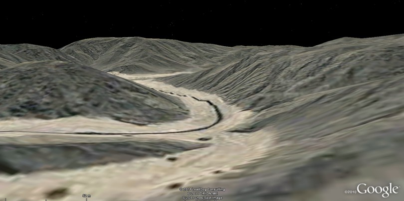
Entering Wadi Watir from the north
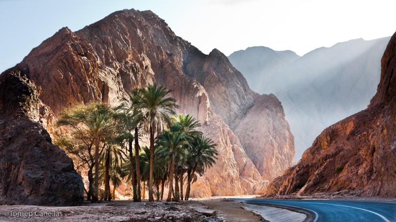
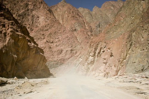
Wadi Watir at ground level (Google Earth photo - Tomed Canellas) The Newabaa Taba Road would have led the Israelites into a very large and wide wadi, the Wadi Watir, which threads its way through the rugged terrain all the way to the Gulf of Aqaba coast. Here it opens out onto an extensive beach, Nuweiba Beach, that, at around ten square miles in area, appears to have been prepared over millions of years by the Holy One of Israel for this year, this month, this day, this hour. Once you have seen this spot you will surely concur; Nuweiba Beach has to be the place.
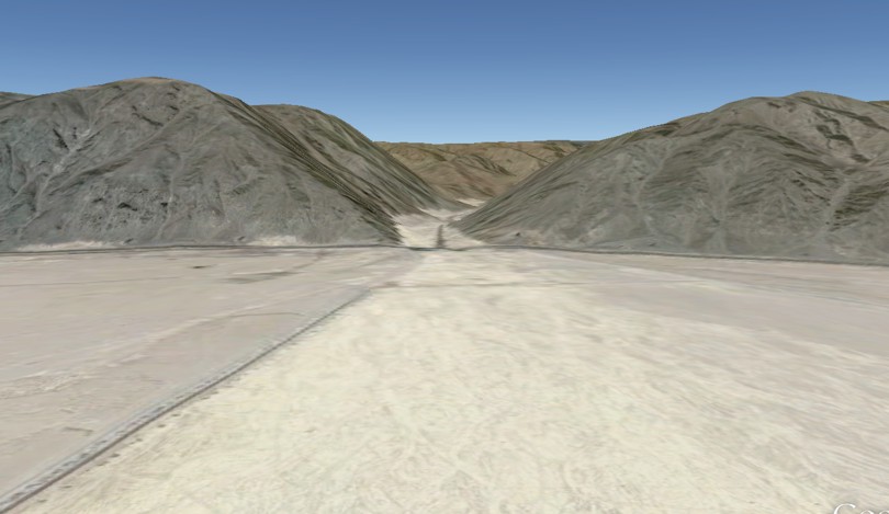
Google Earth View from 25 miles elevation of Nuweiba Beach and Wadi Watir Here, with rugged mountains locking them in on the west and the deep sea to the east, the Israelites would have watched in horror as the Egyptian army galloped into view along the Wadi Watir towards them. The sole way of escape, a ribbon of beach wending along the gulf towards the north, would undoubtedly have been blocked by an Egyptian regiment, as described by Josephus: They also seized on the passages by which they imagined the Hebrews might fly, shutting them up between inaccessible precipices and the sea; for there was [on each side] a [ridge of] mountains that terminated at the sea, which were impassable by reason of their roughness, and obstructed their flight. So there was sorrow and lamentation among the women and children, who had nothing but destruction before their eyes, while they were encompassed with mountains, the sea, and their enemies, and discerned no way of flying from them (Ant., II, XV, 3).38 This description perfectly fits a Nuweiba Beach assembly area. How seriously one can take Josephus as a source of reliable information is a matter of considerable dispute. As Steve Mason puts it, Perhaps the most frequently asked question about Josephus concerns his reliability. But this deceptively simple question entails half a dozen others, each requiring a different answer (1997). He concludes, Nevertheless, it should not surprise us if Josephus turns out to be accurate, by and large, in his description of the world he knew. Archaeologists are delighted to find remains of the Masada, Herodium and Caesarea mentioned in Josephus's narratives - but what else would we expect? Even if his writings are historical novels, playing fast and loose with the facts, we would expect them to refer to real situations, institutions and events. If we accept the credibility of his account, all traditional crossing points are hereby consigned to the dustbin of scholarship. None of them begins to match his description, with nothing but gentle sand stretching for miles to the west of both the Great Bitter Lake and the Mediterranean lagoon. Nuweiba Beach does. Exodus 14:9-12 describes the scene: So the Egyptians pursued them, all the horses and chariots of Pharaoh, his horsemen and his army, and overtook them camping by the sea beside Pi Hahiroth, before Baal Zephon. And when Pharaoh drew near, the children of Israel lifted their eyes, and behold, the Egyptians marched after them. So they were very afraid, and the children of Israel cried out to the Lord . Then they said to Moses, "Because there were no graves in Egypt, have you taken us away to die in the wilderness? Why have you so dealt with us, to bring us up out of Egypt? Is this not the word that we told you in Egypt, saying, 'Let us alone that we may serve the Egyptians?' For it would have been better for us to serve the Egyptians than that we should die in the wilderness." (Ex. 14:9-12) This Google Earth image looking back towards Wadi Watir from Nuweiba Beach gives a general feel for what the Israelites would have seen — if we could only imagine the Egyptian army coming into view — in the moments before the pillar of cloud and fire moved to block the exit. Since this is based on satellite imagery it can only give a general feel. Note that the hills on both right and left of the wadi actually rise over 800 feet above the beach. Here is an excellent ground-level photo showing exactly why the Israelites were blocked in by the mountains.
All was not lost, however; God's planning soon became apparent. Within minutes a dramatic scene unfolded: And the Angel of God, who went before the camp of Israel, moved and went behind them; and the pillar of cloud went from before them and stood behind them. So it came between the camp of the Egyptians and the camp of Israel. Thus it was a cloud and darkness to the one, and it gave light by night to the other, so that the one did not come near the other all that night (Ex. 14:19-20). Oh that one could go back in time to the beach encampment and gaze towards the Wadi Watir; a pillar of warming fire is all you would see. Oh that one could stand in the canyon cheek-by-jowl with the Egyptian army and look towards the beach; an impenetrable wall of indelible blackness is all you would see. Yes, the weight of evidence supports a Red Sea crossing beginning at Nuweiba Beach, a thrilling idea when once it has been embraced and pondered. More information concerning the nature of the underwater topography here, together with further arguments against a Strraits of Tiran crossing point, can be found at "A path through the sea". Bottlenecks ahead!We need to readdress the bottleneck problem. A study of the Wadi Watir shows that its width varied from one thousand feet maximum right down to about one hundred feet at its narrowest. One narrow stretch continues for about six miles. If walkers were separated by a few feet, at the narrowest point thirty people alone could pass through at a time. Maybe they squeezed sufficiently close together to allow sixty people to walk side-by-side. Allowing one such row to pass any given point every two seconds, 21,600 rows would be able to pass in a twelve hour period, translating into nearly 1.3 million people. Calculating the impact of carts and animals, one must slash that total, surely, to half a million people. How far could a couple of million people travel along a narrow stretch of canyon in the course of a day? No idea. We are getting into mathematics that are way too complex for this author. Of course, if the total number of Israelites involved in the Exodus was only about 70,000, as Wenham suggests, this problem melts away. One must remember, too, that it is not a simple case of trying to squeeze everybody through wasp-waisted defiles. The fit (which would have included all but the very young and very old) could have scrambled up and over the rocks in narrow ravines, increasing the rate of progress. In addition, no natural universal law would have forced the entire assembly to follow the same route. The pillar of cloud and fire may well have broken up into a number of pillars to lead different groups different ways. Google Earth reveals a number of side wadis joining Wadi Watir from the east. These wadis begin at the top of an eastern range of hills that stand about 1200 feet above the level of Wadi Watir from where they descend into Wadi Watir, getting wider as they go.39 One again, regiments of the younger and fitter could have branched off into these wadis, climbed up and over the top and then descended towards the coast by means of east-running wadis and then followed the ribbon of beach running south to Nuweiba Beach. True, the going would have been considerably tougher, but for the rock hoppers it would have been a barrel of fun. The carts, animals and elderly would have followed the course of the wider, more level Wadi Watir. The wadi may have served as a road at that time to provide access to a possible shallow-water port in the vicinity of Nuweiba. The ancients were keen mariners.
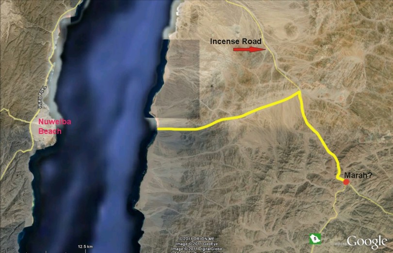
Yes, the going would have slowed on the Etham to Nuweiba leg. But if they had moved at a decent clip on the flat terrain to Etham they could have had a week to negotiate the sixty miles from Etham to Nuweiba. The route from crossing point to Mount SinaiThe psalmist recounts the Red Sea crossing and its immediate aftermath: The waters saw You, O God; the waters saw You, they were afraid; the depths also trembled. The clouds poured out water; the skies sent out a sound; Your arrows also flashed about. The voice of Your thunder was in the whirlwind; the lightnings lit up the world; the earth trembled and shook. Your way was in the sea, Your path in the great waters, and Your footsteps were not known. You led Your people like a flock by the hand of Moses and Aaron (Ps. 77:16-20). The NKJV makes this comment about the last verse: The crossing of the Red Sea was a violent conflict; in this verse, the mood is calm as the Shepherd of Israel leads His people through the desert. The frantic race for freedom may have been won, but Israel's trials were far from over. However, their Shepherd was going to be with them every step of the way. Where did they go, what did they see, how did they survive during their wilderness wanderings? What does the Bible tell us about the route taken from the crossing point to Har Kodesh? A comparison of the biblical data shows a poor fit with reconstructions that took them down the east side of the Gulf of Suez and a brilliant fit with the reconstruction that takes one south through ancient Midian. Oh I do like to be beside the seasideThe most telling piece of data for reconstructing the route from the Red Sea can be found in Numbers 33:10. Following a week or so of journeying, They moved from Elim and camped by the Red Sea. This one fact scuttles the Gulf-of-Suez-crossing idea. Check Google Earth and you can easily see that, apart from the stretch between Gharandal and Abu Zenima, they would have camped by the seaside night after night en route to Jebel Musa. The idea that they may have struck inland for up to a week before heading back towards the sea again stretches credulity. Franz's claim40 that "a stop at the Red Sea, at the mouth of Wadi Sudr41, on the way to Jebel Sin Bishar [his Mount Sinai] makes perfect geographical sense" seems extremely frail to this writer, especially when you consider that it is located merely 23 miles from his Suez crossing point, a distance they could have travelled in one day at a fast clip. Numbers 33 is clear that the Israelites chanced upon the Red Sea again after journeying for some days away from the Red Sea. How did that happen? Let's reconstruct the probable path taken from the Red Sea back to it again. After spending a day or two on the beach composing songs of praise to God, Moses brought Israel from the Red Sea; then they went out into the Wilderness of Shur. And they went three days in the wilderness and found no water (Ex. 15:22). From the beach head,42 one direction alone took them "from" the Red Sea - directly east. After climbing gently for about fifteen miles as the crow flies from sea level to an elevation of about 3000 feet, they would have come upon the ancient incense road that sliced in a north-south direction through the middle of Midian following the wide, dry Wadi l-Abyad. (Modern Highway 5 undoubtedly follows exactly the same route for much of its length. Make sure "Roads" are checked in Google Earth to find it.) Sawyer tells us, The Midianites of the late Bronze and early Iron Age lived along the "incense road" and participated in the trade passing along it (p. 151). This road followed the Wadi l-Abyad, which " runs from north to south, parallel to the coast, and furnished the only practicable route for traffic in this mountainous region" (p. 11). In Moses' time, it would seem this road ran all the way from the south of the Arabian Peninsula to Petra in the north, with a branch near Eilat heading west towards Egypt (the very road the Israelites undoubtedly travelled to get to Etham). Over the centuries it grew and branched; in the first century B.C., "Strabo compared the immense traffic along the desert routes to that of an army".43 (By that time, however, the road appears to have moved east of Midian.) When the Israelites reached this road they could have turned left (north) or right (south). Which way did they go? Since their ultimate destination was the Promised Land, located directly north, one might expect them to turn that way, particularly when you consider that if they did so, they would once again run into the Red Sea, as Scripture says they actually did. A few factors militate against a turn to the north:
They must have turned south down the incense road, which would have put them on a collision course with the Red Sea proper, as Numbers 33:10 requires. (Scroll down to overview picture at the bottom of this page to see why they would have "bumped into" the Red Sea again.) No other reconstruction fits the biblical record so perfectly and so naturally.
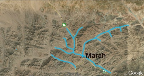
Can we, then, fill in any of the other stopover points between seashore arrival point and seashore encampment? Once again, we will consult Numbers 33: They departed from before Hahiroth and passed through the midst of the sea into the wilderness, went three days' journey in the Wilderness of Etham, and camped at Marah. They moved from Marah and came to Elim. At Elim were twelve springs of water and seventy palm trees; so they camped there. They moved from Elim and camped by the Red Sea (vss. 8-10). Here the Wilderness of Shur (Ex. 15:22) is dubbed the Wilderness of Etham, for reasons we must guess at. The total distance traveled from sea to sea is a little over ninety miles, and would have taken them roughly ten to twelve days, including the brief respite following the crossing. Pinpointing Marah and Elim cannot be done with any certainty. However, we can make some educated guesses. The discovery of water, albeit undrinkable at Marah after three days of passing through waterless terrain (Ex. 15:23) makes perfect sense. For some distance south from the beach landing, the land slopes steadily towards the sea from higher elevations inland. Runoff would drain away quickly and run straight across the road in its dash to the sea, meaning that finding water here would be most unlikely except immediately after rain. However, when you reach a place while travelling south called Ash Sharaf today,44 the topography changes. From here on, higher elevations flank both sides of the road, meaning that runoff flows onto it from both east and west and then turns south and follows the path of the road. This topography explains why Wadi l-Abyad is so wide (about 500 yards on average), making for easy travelling for the Israelites. This intriguing account makes a lot of sense of the biblical data: The great Czech explorer Dr Alois Musil, Professor of Oriental Studies at Charles University in Prague, undertook an expedition to Midian in 1910. In his book, The Northern Hegaz, he describes how along this trade route in the spring there are rain pools in various riverbeds, although these usually dry up at other times of the year (Humphreys 2003, p.50). The Israelites passed by in spring. Ash Sharaf could very well be Marah, with incoming wadis converging from a number of directions. It is the first place on the route where these conditions mean water was likely to have gathered in shallow depressions. The water may have picked up minerals while trickling over the rocky terrain that made it bitter. At thirty miles from the seashore, Ash Sharaf nicely fits the three days climbing and walking mentioned in Scripture. The conjunction of a number of wadis at that point would have provided sufficient "tentacle space" for camping, too.
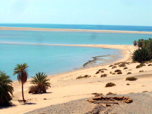
The next place listed as a camp site is Elim, where the happy hikers found twelve wells and seventy shady palm trees. One has fair reason to identify it with modern Al Bad.45 Check it out at low elevation and you will see plenty of vegetation supported by groundwater, as one would expect. This modern town is located about 37 miles walk from Ash Sharaf, about three days worth of walking. Either sweet water was been found between Marah and Elim or they had filled their water skins at Marah. The presence of so many wells at Elim - for herds and flocks - suggests human habitation in the area. Groundwater seems plentiful enough there today; in Moses' time it was likely more abundant, suggesting that a city stood nearby. The open, flat topography certainly lends itself to extensive habitation. The abundant groundwater may well be explained by its position near the receiving end of a large catchment area. It all fits; beautifully. What a wondrous sight it must have made - untold thousands of tents pitched in the river plain next to a bustling city. The ties Moses had with the Midianites by marriage no doubt helped prevent conflict from flaring up. The good money the Israelites would have paid for water would not have gone astray, either. As an aside, Kerkeslager is convinced that Al Bad is one and the same as an ancient city named Madian (Madiam) where, he believes, Moses' father-in-law, Jethro the priest, hailed from. The connection is unlikely, as Josephus locates the city on the Red Sea ( Ant., II, XI, 1). Furthermore, Jethro journeyed from his home to Mount Sinai to talk with Moses (Ex. 18). If Al Bad was his home, he merely had to go out of his house and through the city gate to see his son-in-law. One cannot help but wonder if the thriving city of Madian might have been located around modern Al Maqna,46 about fifteen miles from the nearest point on the incense road.
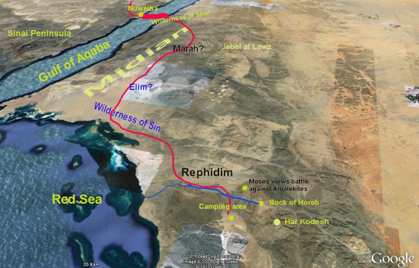
Next stop on the incense road - sun, sand, and swimming at the Red Sea. At about 27 miles from Al Bad, it could have been reached in a couple of days with ease. Your own imagination, inspired by a couple of pictures, can fill in the details of a day or two by the Red Sea. The critically important point to be made is that the route being proposed here makes the most sense of a return to the Red Sea a week or so after departing from it. The landscape en route looks particularly forbidding, as can be seen with ease on Google Earth and from pictures taken at ground level. One must remember, however, that climate change may well have reduced rainfall since that time. Brad Sparks tells us that. "The truth is that there was a much wetter climate in ancient times, in the Sinai and elsewhere. which sustained much more vegetation than at present".47 Assuming he is correct, the scene that greeted the Israelites back then may well have been considerably more welcoming than it appears today. However, groundwater here must have provided refreshment for both man and beast as the Bible gives no indication of complaints over water until they reached Rephidim. A close-up view shows evidence of such water in the vicinity.48 They did, however, grumble about lack of food at the next stopover point: Then the whole congregation of the children of Israel complained against Moses and Aaron in the wilderness. And the children of Israel said to them, "Oh, that we had died by the hand of the Lord in the land of Egypt, when we sat by the pots of meat and when we ate bread to the full! For you have brought us out into this wilderness to kill this whole assembly with hunger" (Ex. 16:2-3). Exactly what the Israelites had been eating till now is not made clear. At the beginning of their flight from Egypt they ate unleavened bread (Ex. 12:39). They may have supplemented the supply of flour and spelt, carried in the carts, with bought food from friendly natives, too. After all, they had plenty of "money". However, nobody could supply such a large number of people indefinitely. Whatever the details, immediately after the Red Sea encampment they began to bellyache about aching bellies. You know the outcome: manna. From then until they crossed the Jordan River forty years later, God gave His people a daily dose of delicious dough. Numbers 33 completes the list of campsites between the Red Sea and Mount Sinai: They moved from the Red Sea and camped in the Wilderness of Sin. They journeyed from the Wilderness of Sin and camped at Dophkah. They departed from Dophkah and camped at Alush. They moved from Alush and camped at Rephidim, where there was no water for the people to drink. They departed from Rephidim and camped in the Wilderness of Sinai (11-15). The precise location of the Wilderness of Sin, Dophkah and Alush is a matter of conjecture as we are given no specifics at all. Whether the Israelites headed directly east from the Red Sea camp and then south, or whether they continued on down the incense road until the time came to branch off is impossible to say. Let us conclude this part with a picture that combines all the information presented both above as well as anticipating more that will appear in Part Four to provide an overview of the general route from the beach to Har Kodesh together with places of major interest en route. (Text colors vary purely for purposes of providing contrast against background.)
33 According to the University of Minnesota Media History Project, "The first known use of pigeons as postal messengers was in ancient Egypt. In 2900 B.C.E. in Egypt, incoming ships released pigeons as an announcement of important visitors. Around the time of Moses, the Egyptian army used carrier pigeons to deliver messages." [Back] 34 The Exodus Route [Back] 35 Exodus Route map [Back] 36 Coordinates: 29 38 57 34 41 26 [Back] 37 Coordinates: 29 26 30 34 50 31 [Back] 38 pp 62-63 [Back] 39 For example, at 29 10 33 34 30 24 and 29 16 33 34 30 39 [Back] 40 The Chronology from Rameses to the Red Sea [Back] 41 Coordinates: 29 37 22 32 45 07 [Back] 42 Coordinates: 29 01 52 34 51 11 [Back] 43 Romans in Arabia [Back] 44 Coordinates: 28 55 27 35 10 48 [Back] 45 Coordinates: 28 27 54 35 00 39 [Back] 46 Coordinates: 28 23 57 34 44 44 [Back] 47 PROBLEMS WITH MT. SINAI IN SAUDI ARABIA [Back] 48 Coordinates: 28 09 41 35 02 31 [Back] |

|
|
|
Dawn to Dusk publications |
Other printed material |
On the Web |
|
|
|
|
| Edited and expanded copies of this article, in reprint pamphlet form, can be purchased by going to the reprints order page. As well as reprints, Dawn to Dusk offers books in printed form and on CD-ROM. We mail to anywhere in the world! For more information on what is available, prices, and how to order, click the icon. |