 |
Mt Sinai, Kadesh Barnea, and the ExodusPosted: 11th October, 2012 |
 |
The full version is broken into two parts due to its length (over 15,000 words). It covers each point in more detail in addition to dealing with a number of matters not mentioned in the short version. |
|
Almost everyone admits that an Exodus occurred. But the details of the journey are presented in such a way that relating them either chronologically or geographically to known historical data is indeed difficult. Yehuda Radday, A Bible Scholar Looks at BAR 's Coverage of the Exodus DIFFICULT, INDEED. But not impossible. After all, we have established that Israel's journeys took them into ancient Midian (Where is Mount Sinai?) and we have a clear bead on one location mentioned on the route of Israel's journey Ezion Geber (Num. 33:35). Add a known starting point and a known end point, and you're half way there. This article has the limited purpose of making sense of the biblical data about the route taken by the Israelites after leaving Mount Sinai and so, by extension, to making a contribution to the cause of the Bible's credibility. Rejectionists ridicule the biblical narrative as riddled with error. Oh that they would cease from their stubbornness and approach the Word of God with fear and trembling; then they would see and sing God's praises rather than continuing to stumble in the dark. Golgotha hill is of infinitely more significance than towering Mount Sinai, and Jesus' short walk to Calvary of immeasurably greater moment than Israel's forty years wilderness march. Nevertheless, after the atoning and saving work of the only Son of God, the redemption of Israel from Egypt and her eventual safe arrival in the land promised to Abraham's seed must go down as the ultimate historical event. Kadesh BarneaWe shall begin with a critical aspect of the post-Sinai narrative the significance of Kadesh Barnea. We will get to the location of Kadesh Barnea later; for the moment we are concerned merely with establishing some basic facts about the place. The Bible focuses a bright spotlight on this place. Deuteronomy 1:19-21 presents it as Israel's most important port of call between Mount Sinai and the Holy Land: So we departed from Horeb [Mount Sinai], and went through all that great and terrible wilderness which you saw on the way to the mountains of the Amorites, as the Lord our God had commanded us. Then we came to Kadesh Barnea. And I said to you, You have come to the mountains of the Amorites, which the Lord our God is giving us. Look, the Lord your God has set the land before you; go up and possess it " It would appear that they arrived there about twelve months after departing Mount Sinai, two years after leaving Egypt in what has become known as "the Exodus". Soon after, disaster struck. From Kadesh Barnea, Moses sent spies to reconnoiter the land. When they returned, they tarnished their glowing report of the land's superb assets with fearful accounts of the prowess and overwhelming strength of its inhabitants, many of whom were so tall the spies felt like grasshoppers by comparison (Num. 13).
The people felt so sorry for themselves they refused to budge (Num. 14). At that point, God postponed the conquest, sentencing the entire nation to a total of forty years of rough country living, during which time every person who had been over the age of twenty upon departing from Egypt would die (Num 14:26-35). Ahead of them lay thirty-eight more years of wandering in unfamiliar surroundings. Many of those years were to be spent in Kadesh Barnea. Exactly how long they spent at Kadesh Barnea remains moot. Most Christian commentators take Deuteronomy 2:14 to suggest a thirty-eight-year-long stopover: And the time we took to come from Kadesh Barnea until we crossed over the Valley of the Zered was thirty-eight years This ambiguous statement, made shortly before the conquest, could be taken to suggest a thirty-eight-year stopover. Jewish students take a different tack, taking their cue from Deuteronomy 1:46: So you remained in Kadesh many days, according to the days that you spent there. Taking the highly-influential medieval French rabbi, Rashi, as their source, some Jewish commentators take the clause according to the days that you spent there to mean that they spent as much time there as they did at all other places combined. Thus, they spent a total of nineteen years at Kadesh Barnea. Makes sense, doesn't it? More than one KadeshWe need to remove an obstacle upon which a surprising number of scholars stub their toes treating two separate places sharing the same name as if they were one place. Any reconstruction that treats two different places as if they were one and the same cannot help but come to grief. Numbers 33 provides a list of stopover points all the way from Egypt to the Promised Land. After leaving Mount Sinai, twenty stations are listed, after which, They moved from Ezion Geber and camped in the Wilderness of Zin, which is Kadesh (vs. 36). One could certainly be forgiven for taking this Kadesh to be one and the same as the Kadesh Barnea already discussed. Numbers 13 and 14, which speak unmistakably of events that occurred at Kadesh Barnea, show that it was sometimes referred to as simply Kadesh (13:26). And since no other Kadesh is referred to in Numbers 33 before the Kadesh mentioned in verse 36, it makes sense that this Kadesh is the same as the Kadesh Barnea spoken of in earlier chapters of Numbers. But it isn't; it's a different Kadesh, as an examination of various lines of evidence will show and as is recognized by a number of Bible students, particularly Jewish. One must conclude that Kadesh Barnea is listed in Numbers 33 under a different name. Working with average distances between stations suggests that Terah (Num. 33:27) is the most likely candidate, but we cannot know. Frankly, it doesn't really matter.
Alternatively, Kadesh Barnea could be a specific name, possibly of a watering hole or the like, that was located in a district of a different name, in the same way that San Rafael is a city in Marin County, and Numbers 33 uses the district name. In short, the lack of appearance of the name Kadesh Barnea in verses 16-35 of Numbers 33 is no major impediment to the view presented here. Reconstructing the trailTo have any chance of plotting the route taken by the Israelites with any degree of accuracy you must have at least a few dots, representing points on the route, you can be confident of. Enlightened sleuthing can then be employed to add more dots with some degree of accuracy. Finally, you join the dots. Of critical importance is the starting point; get it wrong and you will be off on a wild goose chase. We already have Mount Sinai marked on the map.1 Where do we go from there? We will start with the key facts presented in Deuteronomy 1:2: It is eleven days' journey from Horeb by way of Mount Seir to Kadesh Barnea.
This verse provides two critical clues that need to be carefully considered: • The distance These clues won't enable us to triumphantly thrust a pin into the map but will give us a very helpful guideline which can be further refined by other hints. The distanceHow far was a day's journey? Nobody knows for sure, but we can be fairly confident of establishing a range of possibilities. We will take the position found in The Illustrated Bible Dictionary, which says, Presumably a day's journey was between eighteen and twenty-five miles. Using this range as our guide leads us to search for Kadesh Barnea somewhere between 200 (198 to be precise) and 275 miles walking distance from Mount Sinai along the most logical route. The directionThe Deuteronomy passage reveals that the Israelites traveled by way of Mount Seir. The Hebrew construction, derekh ha-Seir, can be read a few different ways. • they went via Mount Seir, or, We propose that the evidence suggests that in this passage the term is referring specifically to a road that served as a major trading route linking the fabled land of Sheba and other regions in the south-west of Saudi Arabia with Egypt, the Levant, and Syria (the NIV interpretation). This ancient caravan route began in Shabwa in southwestern Arabia and swept north parallel to the Red Sea coast passing through the El-Ola oasis on the way. See Figure 4 for an overview of the route. Commonsense suggests that the Israelites followed this trading road leading to Mount Seir for at least part of their march towards Kadesh Barnea. Whether they stopped shy of Mount Seir or shot beyond it cannot be determined from the direction component of the Deuteronomy passage. Figure 5 outlines the most likely route taken by the Israelites, in the rough, from Har Kodesh towards Kadesh Barnea. Putting the two togetherWe are going to find Kadesh Barnea somewhere in the direction of Mount Seir, between roughly 200 and 275 miles from Har Kodesh2 taking the most sensible route, first, from Har Kodesh to the trade route and then, second, following the trade route, Mount Seir Road, towards Edom, and possibly beyond. No guesswork is required to figure out the route taken from Har Kodesh to the Mount Seir Road. The reader is encouraged to dust off Google Earth and paste these coordinates into it: 27 50 38 35 35 25. Zoom in or out as needed to an eye altitude of about 8 miles (12 kilometers). You are looking at the western edge of the Mount Sinai camping area. Now make sure "Roads" is enabled and you will see a faint yellow line running through the camping area. This line marks out the path of a road running generally east-west and which connects two major north-south highways. The Israelites would undoubtedly have taken the same route. Follow this road towards the east until it meets Highway 80.3 (See Figure 6.) From here to the top of the plateau is another four miles. The first stop upon reaching the plateau was Kibroth Hattaavah. When the Israelites whined about the lack of meat here, God whipped up a quail tempest (Num. 11:31). Upon leaving Kibroth Hattaavah they would most likely have made a beeline across the flat landscape to the ancient town of Qurayyah, 4 located about 38 miles north west of modern Tabuk. The on-the-ground distance from Har Kodesh to Qurayya, following the path of the modern road, is about 110 miles. Now all we need do is to proceed from Qurayyah towards Mount Seir along the Mount Seir Road, taking the minimum value for a day's journey (18 miles) to mark the southernmost point of the range of likely locations for Kadesh Barnea and the maximum value (25 miles) for the northernmost. Following the probable route of the Mount Seir Road, the short value brings you to the vicinity of the modern city of Maan, Jordan, 5 which was very close to the Edomite border, and from where the trading route plunged into Edom and proceeded onto the famed rose-red citadel of Petra. 6 If a day's journey was greater than the 18 mile value, they probably would have taken a route that bypassed Maan ten to fifteen miles to its east and headed north across the vast, flat desert. Following that route, and taking the longest value for a day's journey, would have brought them to Al Qatrana, Jordan. 7 In sum, we can establish a 75-mile, north-south zone of potentiality for the location of Kadesh Barnea. See Figure 7 for clarification of the range of potential sites. Where is it, then?Where, then, is Kadesh Barnea ? Can we narrow down its likely location any further than we have already done? Yes, we can. To do so requires introducing a totally new idea into the equation: in Moses' day, a tiny territory occupied by Canaanites and Amalekites was sandwiched between the petty states of Edom (Mount Seir) in the south and Moab in the north. For the sake of convenience, we will dub this territory Canamalia a better choice, wouldn't you agree, than the logical alternative, Amoria. We propose that Kadesh Barnea lay a little east of Canamalia's eastern boundary.
Where would the eastern boundary be located? It is impossible to know precisely how far east the borders of these small states extended at that time, but we cannot be far off the mark to say that they would almost certainly not have gone any further east than the modern Desert Highway in Jordan (Hwy 15), which lies roughly thirty to thirty-five miles east of the great rift valley in which the Dead Sea and the Arabah lie. No known site of any major town from that period is found east of that highway, and most lie between ten and twenty miles to its west. 8 We can safely set the eastern border of all three of these principalities no further east than the Desert Highway. Figure 8 shows the approximate extent of the well-known states of Edom and Moab as well as of the proposed state of Canamalia. (Figure 3 shows Canamalia in greater detail; there it is designated the mountains of the Amorites.) On what basis can we posit the existence of the Amalekite/Canaanite kingdom of Canamalia? How does this proposal aid our cause? The argument is straightforward enough. Consider these points. 1. Deuteronomy 1:20-21Remember this important passage? When the Israelites arrived at Kadesh Barnea, Moses told them, You have come to the mountains of the Amorites, which the Lord our God is giving us. Look, the Lord your God has set the land before you; go up and possess it, as the Lord God of your fathers has spoken to you; do not fear or be discouraged. Neither Edom nor Moab was on Israel's radar screen as part of their divinely-ordained possession; Israel was not to inherit a foot's worth of either territory (Deut. 2:5, 9). If these states were joined at the hip, thus creating a continuous wedge separating Kadesh Barnea from the Holy Land to the west, Moses could not have said, You have come to the mountains of the Amorites. Canamalia solves the problem simply and elegantly. This mountain of the Amorites consisted of an extension towards the east of territory occupied by Canaanites and Amalekites in the northernmost part of the valley of the Arabah(Num. 14:25). Geography provides logical constraints for establishing Canamalia's northern and southern borders. The border between Edom and Canamalia would have lain along Wadi Dana. The border between Canamalia and Moab undoubtedly coincided with Moab's classical southern boundary Wadi al-Hasa. (See Figure 9 relief map showing these natural boundaries reasonably clearly.) These two gorges, then, make for logical limits to Canamalia country. If correct, Canamalia attained a maximum north-south dimension of about seventeen miles. Its westernmost boundary would have fallen roughly in line with the Arabah. Its eastern boundary was probably near the modern Jordanian town of Al Hasa.9 Canamalia's breadth would then be roughly thirty to thirty five miles. The topography of this proposed southeastern tail of the Promised Land matches the description given in Numbers 14:40-45 concerning the Israelite attempt to storm it from Kadesh Barnea: And they rose early in the morning and went up to the top of the mountain, saying, Here we are, and we will go up to the place which the Lord has promised, for we have sinned! And Moses said, Now why do you transgress the command of the Lord? For this will not succeed. Do not go up, lest you be defeated by your enemies, for the Lord is not among you. For the Amalekites and the Canaanites are there before you, and you shall fall by the sword; because you have turned away from the Lord, the Lord will not be with you. But they presumed to go up to the mountaintop Then the Amalekites and the Canaanites who dwelt in that mountain came down and attacked them, and drove them back as far as Hormah (Num. 14:40-45). This account shows that from their camp at Kadesh Barnea they had to go up into the top of the mountain/highlands. The proposed location of Kadesh Barnea, soon to be revealed, is at an altitude of about 850 meters, while Canamalia is around 1200 meters elevation, requiring that they go up to reach it. Equally important in supporting this location is Deuteronomy 1:44, which states that the enemy, drove you back from Seir [Edom] to Hormah. In spite of the uncertainty surrounding Hormah's whereabouts, this battlefield description suggests that the Israelites attempted to storm the highest peak in Canamalia (1480 meters)10 located a stone's throw from Canamalia's proposed border with Edom, but were beaten back from Edom. Fits perfectly. 2. The route to the plains of MoabAll scenarios agree in their fundamentals when it comes to the last leg of the journey a flanking movement around the eastern side of Moab starting from the Arabah somewhere south of the Dead Sea and ending alongside the Jordan River six or seven miles north of the Dead Sea. The question is, how did they get to the eastern side of Moab from the Arabah without passing through either Edomite or Moabite territory? That they did not enter either Edomite or Moabite territory at any time during their march is made clear in Judges 11:14-18: So Jephthah again sent messengers to the king of the people of Ammon, and said to him, Thus says Jephthah: Israel did not take away the land of Moab, nor the land of the people of Ammon; for when Israel came up from Egypt, they walked through the wilderness as far as the Red Sea and came to Kadesh. Then Israel sent messengers to the king of Edom, saying, Please let me pass through your land. But the king of Edom would not heed. And in like manner they sent to the king of Moab, but he would not consent. So Israel remained in Kadesh. And they went along through the wilderness and bypassed the land of Edom and the land of Moab, came to the east side of the land of Moab, and encamped on the other side of the Arnon. But they did not enter the border of Moab, for the Arnon was the border of Moab' (Jdg. 11:14-18). Jephthah, a judge of Israel, spoke these words a couple of hundred years after Moses' time. Note carefully that the Israelites bypassed both Edom and Moab when their respective kings refused to give permission to pass through their territory.
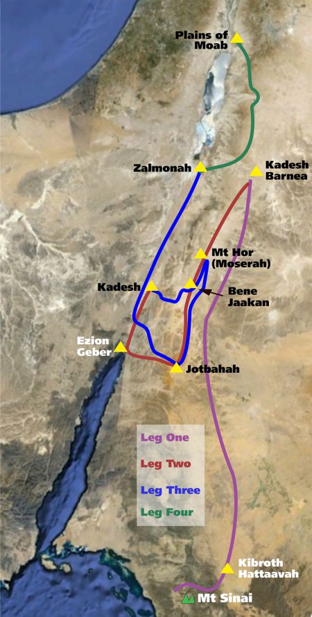
With these facts up our sleeve, we are virtually forced to draw the same conclusion as before; an Amorite enclave separated Moab in the north from Edom in the south. For some unexplained reason, the Israelites were able to ascend unimpeded through this rugged territory to bring them to the east of Moab even though, nearly forty years earlier, they had exchanged blows with Canamalia's inhabitants. Time can do strange things when it comes to international relations. Hot on the trailFinally, we are ready to narrow down the location of Kadesh Barnea: it must lie east of Canamalia. If our theory as to the location of Canamalia's northern and southern borders along natural topographic features is correct, then the eastern border of Canamalia lay roughly between the modern towns of Al Hasa in the north and Jurf Al Darawish11 to the south. Now we're getting somewhere. But we can narrow our search down much further. What one requirement above all others is essential to life? You're right. Water. So fire up your Google Earth and looky here: 30 48 37 36 00 34. You have an area of about three square miles covered with trees. Trees mean water. Figure 10 provides a view of the trees from about 5 miles in altitude. The water from here flows west, going right through the center of Al Hasa. Following the bed further west shows that flowing water coming from the woods has, over time, cut into the bedrock. Even an ephemeral flow would have sufficed to provide a permanent supply if cisterns were dug or impoundments built. The evidence piles up to suggest we can place Kadesh Barnea somewhere in the vicinity of the extensive woods near the modern town of Al Hasa. The modern Desert Highway right nearby probably traces the route of an ancient trading road. Before the Israelites arrived, Kadesh Barnea may well have been a resting place for merchants. It fits. Who can see any fatal flaws? From here on, the names Kadesh Barnea and Al Hasa will be used interchangeably. From Sinai to the Promised LandWe are now ready to follow Israel's trail from Mount Sinai all the way to the Jordan River opposite Jericho. We have already discussed the general route taken from Har Kodesh to Kadesh Barnea, and no further comment will be made about it. We will divide our remaining travelogue into three sections: • Kadesh Barnea to Kadesh. Although we can trace the route taken from Har Kodesh to Al Hasa with some confidence, marking the stopovers on a map would be a matter of guesswork. The picture begins to change with Moserah, or Moseroth (Num. 33:29), fifteen campsites from Mount Sinai and six stops before reaching Ezion Geber. From Moserah we can make some seriously educated guesses. Figure 11 gives an overview of the circuitous path, split into four stages, taken from Mount Sinai to the Promised Land. From Kadesh Barnea to KadeshWe'll start with an overview, and then move on to cover this leg in more detail. After spending many years at Kadesh Barnea, Israel received her marching orders: Then we turned and journeyed into the wilderness of the Way of the Red Sea, as the Lord spoke to me, and we skirted Mount Seir for many days (Deut. 2:1). This passage gives us a fairly good idea which way they went, and suggests that they took some years to do it. We have already proposed that the modern Desert Highway lay a little to the east of Edom's eastern border. Since this passage says they skirted Mount Seir for at least part of the journey by taking the Way of the Red Sea (Red Sea Road), we cannot go too wrong to take the Desert Highway as a rough guide to their movements after departing Kadesh Barnea. This route south lay approximately thirty miles west of the route they took to the north from Qurayyah. Numbers 33:35 shows that they eventually went all the way to the Red Sea: They departed from Abronah and camped at Ezion Geber. The next verse adds, They moved from Ezion Geber and camped in the Wilderness of Zin, which is Kadesh. Where was Kadesh? Deuteronomy 2:2-3 helps to locate it: And the Lord spoke to me, saying: You have skirted this mountain long enough; turn northward (2:2-3). The words spoken here were said to Moses at Ezion Geber. So, when they left Kadesh Barnea they travelled south roughly parallel to the eastern boundary of Edom, eventually arriving at Ezion Geber. Here, God told them to turn northward. They did not retrace their steps back up the eastern side of Edom but now they headed north up the Arabah along the western side of the Mount Seir escarpment. In spite of the heat, people lived in the Arabah. One such settlement was Kadesh, already spoken about. Taking as our guide the reasonable notion that cities in the Arabah existed to provide succor and supplies to traders, towns would invariably have been placed where trading routes intersected. A trading road ran along the bed of the Arabah from Ezion Geber to the southern end of the Dead Sea where it branched; we will call it the Arabah Road (based on the RSV translation of Deuteronomy 2:8). Kadesh no doubt stood somewhere along the Arabah Road where it was crossed by another trade route.
During the Late Bronze Age the Sinai Peninsula was quite heavily populated; merchants from there who wanted to take the most economical route east to join the north-south trading roads on the Jordanian plateau would naturally have sought out the easiest ways to climb up and across the Mount Seir escarpment. Kadesh would have been located where one such trail heading east crossed the Arabah Road. As you move north from Ezion Geber you come to just such a pass at about the 35 mile mark. We suggest that Kadesh was located at the intersection near the start of that pass.12 Figure 12 shows all the roads spoken of in this article as well as showing, in blue, the proposed trading trail linking the Arabah Road with the King's Highway. Figures 13 and 14 are Google Earth images illuminating this proposed trail. Figure 13 is a view from Kadesh to the start of the trail, while Figure 14 provides a closeup of the landscape a little way further along. Finally, Figure 15 gives a bird's-eye view of the trail, slightly offset from its actual position to highlight the path, all the way from Kadesh to the start of the King's Highway. The significance of this trail will become evident shortly. The route in detailNow that we have set out the general route from Kadesh Barnea to Ezion Geber to Kadesh, let's flesh it out, beginning with Moserah. Moserah can be identified with Mount Hor by putting two passages together: They moved from Kadesh and camped at Mount Hor, on the boundary of the land of Edom. Then Aaron the priest went up to Mount Hor at the command of the Lord, and died there in the fortieth year after the children of Israel had come out of the land of Egypt (Num. 33:37-38). Now the children of Israel journeyed from the wells of Bene Jaakan to Moserah, where Aaron died (Deut. 10:6). You don't have to have a PhD in quantum physics to grasp that either Mount Hor and Moserah are two names for the same place, or that Moserah was a township/trading centre located near a peak known as Mount Hor. To establish the location of Moserah we need to find a suitable peak east of the escarpment. If our whole thesis contains any weaknesses, it is at this point. By contrast with the rugged escarpment making up the western part of Mount Seir, which provides many peaks that could be labeled mountains, the eastern borderlands of Edom are by and large monotonously flat, presenting no peaks that could pass as a mountain by our way of thinking. The problem is not, however, intractable. The solution lies in recognizing that a har, in Hebrew, can be practically anything from a knoll to a hill to a majestic peak. Any prominence that juts above its surroundings is a mountain.
Using the color-by-altitude feature in Natural Scene Designer yields a hillock at 30 12 20 35 36 07 rising a couple of hundred feet above its surroundings. Though its height leaves a little to be desired, its location shows promise, lying close to the border of Edom. Bene JaakanHaving established a location for Mount Hor (Moserah), might we be able to deduce with some degree of confidence where the next stopovers are located? Yes we can. The next stop after Moserah is Bene Jaakan. Fifteen miles from our Moserah along the Desert Highway (Red Sea Road) is a junction where a road coming from the north-west joins the Desert Highway. This road follows the route of one of the most ancient of roads the famous King's Highway. The King's Highway is part of one long trading route that we spoke of in Somewhere, over the Red Sea. It began in Egypt and crossed the Sinai Peninsula to Ezion Geber. There it was met by the incense road coming from southern Saudi Arabia through Midian, the same road the Israelites used to get to Mount Sinai. From Ezion Geber, the King's Highway combined with the Red Sea Road heading north-east for about 45 miles and then forked off on its own towards the north-west before turning due north and winding its way through Edom. After thrusting through the heart of Canamalia, it continued north through Moab all the way to Amman, Jordan (biblical Rabbah). (See Figure 12.) A settlement at this junction would undoubtedly have served as a major merchants' stopover. The Israelites probably camped as close as was practical to this site. The trail coming from Kadesh mentioned earlier would also have converged at this point (Figure 15). It all fits. Hor Hagidgad, Jotbathah, and AbronahThe Israelites seem to have left the Red Sea Road at Bene Jaakan and headed south and slightly east, passing through Hor Hagidgad and then stopping at Jotbathah. The latter can almost certainly be associated with the famous Jordanian holiday destination renowned for its spectacular scenery, Wadi Rum. Deuteronomy 10:7 describes Jotbathah as a land of rivers [wadis] of water. Since no location in that part of the world could possibly enjoy a lot more rain than nearby locations, one must conclude that at least some of the water in this land of wadis of waters must have come from a source other than rain. The only answer can be groundwater. A large aquifer underlies this area of Jordan and neighboring Saudi Arabia. Cracks in the bedrock separating the aquifer from the surface may have allowed water to percolate all the way to the surface in Moses' day. This idea is supported by the fact that water flows slowly but perceptibly from the Saudi side into Jordan. Today it doesn't quite get to the surface at Wadi Rum because it is being pumped out faster than it can make its way upwards; one third of the precious resource has already been used up. Where you plot Hor Hagidgad and Abronah is a matter of educated guesswork. We have plotted them on our map purely as a rough guide. From Abronah they proceeded to Ezion Geber. Deuteronomy 2:7 shows that their arrival at Ezion Geber coincided with the fortieth year, most likely the first month. From Ezion Geber they went on to Kadesh. (Figure 17 shows the proposed route from Moserah to Kadesh in more detail.) From Kadesh to ZalmonahThe most challenging part of the entire exercise of reconstructing Israel's movements during its period of postponement begins here at Kadesh. By comparison, the task of reconstruction has been duck soup up until now. Let's put all the difficult passages on the table and see what we can come up with. First,
Then the children of Israel, the whole congregation, journeyed from Kadesh and came to Mount Hor (Num. 20:22). Are we saying that they left Kadesh and travelled back to Mount Hor (Moserah) where they had camped some years earlier? Yes. That's what it seems to be saying. There Aaron died in the fortieth year after the children of Israel had come out of the land of Egypt, on the first day of the fifth month (Num. 33:38). If our guess that Israel was in Ezion Geber in the first month is correct, Aaron's death at Mount Hor occurred four to five months later. Now stir in Numbers 21:4: Then they journeyed from Mount Hor by the Way of the Red Sea, to go around the land of Edom; and the soul of the people became very discouraged on the way. Are we saying that when they left Mt Hor they once more headed south towards the Red Sea, circling around the land of Edom again before finally returning yet again to the Arabah? Yes, that's what it seems to be saying. This apparent doubling back over old territory presents quite a puzzle. We propose that this puzzle can be solved reasonably easily. Shortly before arriving at Kadesh the first time, God told them they were about to begin the final phase of their odyssey, which was to take them through the heartlands of Edom, Moab, and Canamalia all the way to the Jordan River (Deut. 2:4-6). In accordance with this instruction, when Israel first arrived at Kadesh, Moses sent a letter to the King of Edom: Now Moses sent messengers from Kadesh to the king of Edom. Thus says your brother Israel: You know all the hardship that has befallen us, how our fathers went down to Egypt, and we dwelt in Egypt a long time, and the Egyptians afflicted us and our fathers. When we cried out to the Lord, He heard our voice and sent the Angel and brought us up out of Egypt; now here we are in Kadesh, a city on the edge of your border. Please let us pass through your country. We will not pass through fields or vineyards, nor will we drink water from wells; we will go along the King's Highway; we will not turn aside to the right hand or to the left until we have passed through your territory.' Then Edom said to him, You shall not pass through my land, lest I come out against you with the sword (Num. 20:14-18). Stop and think. You are an Israelite, camped in what you consider a hell hole, waiting for the go-ahead to proceed to your promised inheritance. Your hopes are dashed when the King of Edom rejects your application. Weeks go by, and nothing happens (Jdg. 11:17). Thumb twiddling, rock climbing, and playing rock-paper-scissors quickly lose their appeal. You join a mob to put pressure on Moses to do something. Then someone suggests sending a second letter, this time emphasizing Israel's willingness to pay top dollar for any food and water supplied by the Edomites. Moses acquiesces, and a second letter is sent: So the children of Israel said to him, We will go by the Highway, and if I or my livestock drink any of your water, then I will pay for it; let me only pass through on foot, nothing more (Num. 20:19). This offer is certain to work. So sure are you that Old King Edom will relent that you urge Moses to decide to break camp at Kadesh and head for the point where the King's Highway enters Edomite territory (Bene Jaakan, Figure 12) taking the trading path mentioned earlier; here you wait for an entry visa to be issued. The Edomites' reply was not what you expect: Then he said, You shall not pass through. So Edom came out against them with many men and with a strong hand (Num. 20:20). In the panic that ensued, the Israelites fled toMoserah. There Aaron died, and the people stayed for thirty days to mourn him (Num. 20:29). The Bible is very succinct about what happened next:
So they departed from Mount Hor and camped at Zalmonah (Num. 33:41). Zalmonah must be located somewhere in the northern Arabah. To get there from Mount Hor, the Israelites had to circle around Edom (Num. 21:4), this time giving it as wide a berth as practicable. Based on the testimony of Deuteronomy 10:6-7, we can add these details. From Moserah they trekked south to Gudgodah (Hor Hagidgad) and on to Jotbathah (Wadi Rum), this time bypassing Bene Jaakan-of-the-bad-memories. From Jotbathah they made their way to the Arabah, presumably taking the shortest possible route, and on to Zalmonah. This strange portion of the journey is clarified by examining Figure 18. From Zalmonah to the Jordan RiverDeuteronomy 2:9-13 gives a no-frills summary of the trip from Jotbathah all the way past the northern border of Moab without mentioning a single stopover: And when we passed beyond our brethren, the descendants of Esau who dwell in Seir, away from the road of the plain [Heb., Arabah], away from Elath and Ezion Geber, we turned and passed by way of the Wilderness of Moab Then the Lord said to me Now rise and cross over the Valley of the Zered. So we crossed over the Valley of the Zered (Deut. 2:8-9, 13). Once they had arrived in the Arabah from Jotbathah, they travelled away from Ezion Geber in other words, north, to Zalmonah. We have finally reached a point in the narrative of Israel's wanderings where everybody agrees about the general picture. From Zalmonah, somewhere in the north of the Arabah, the Israelites climbed eastwards up to the Jordanian plateau, then turned north, travelling east of Moab until they had passed Moab's northern border, the Arnon River (modern Wadi Mujib). North of Moab lay the states of Heshbon and Bashan. Israel defeated the armies of both these states (Deuteronomy 2 &3) and finally came to rest in the plains of Moab just east of the Jordan River. The details are still up for grabs and remain the source of considerable debate. Figure 19 gives what must be a reasonably accurate account of this leg of the journey. For forty years the Israelites bore the shame of their rebellion, living under conditions of considerable hardship. In the first 39 years of their wilderness odyssey, they walked about 380 miles. In the last twelve months, they covered around 315 miles. The biggest challenges lay beyond Mount Sinai and Kadesh Barnea — in the Promised Land .
1 27 51 33 35 44 29 [Back] 2 The author's name for the mountain he believes to be Mount Sinai; it means holy mountain. Its coordinates are 27 51 35 35 44 33. [Back] 3 27 48 13 35 59 49 [Back] 4 28 51 12 36 16 37 [Back] 5 30 10 41 35 44 49 [Back] 6 30 19 20 35 28 42 [Back] 7 31 15 04 36 01 37 [Back] 8 Most of the sites east of the Jordan/Dead Sea are located along one or other of a series of north-south-flowing wadis in the highlands at the Eastern Rim of the Wadi ArabahJordan Graben. It was along these wadis that much of the country's agricultural activities took place and, therefore, occupation centres were located. [Back] 9 30 49 16 35 59 14 [Back] 10 30 46 18 35 38 33 [Back] 11 30 41 10 35 52 04 [Back] 12 30 01 44 35 08 52 [Back]
|